
Project PLATEAU | The Initiative of Digital Twin in Japan

Launched in 2020, PLATEAU continues to grow as a platform for the participation of many local governments, private companies, and diverse researchers, engineers, and creators.
PLATEAU is a platform for urban management, consolidation of urban functions, and sustainable urban development.
The digital transformation of city planning based on PLATEAU will solve social and regional issues.
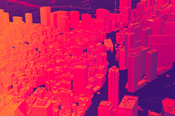
By generating 3D urban models from existing data, we can see the possibilities of cities for the future. As the data is open, the sharing of wisdom and new actions will spread.
By integrating and visualizing urban information, transformed into valuable information for the society of the future.
The 3D urban model will be the foundation of the coming Society 5.0.
It is the beginning of the creation of a society that is sustainable, livable, and inclusive for all.
Map the New World.
PLATEAU will create a new world.The project promotes the digital transformation of urban development by building an ecosystem for the development, utilization, and open data of 3D urban models.
PLATEAU is a 3D urban model development, utilization, and open data project led by the Ministry of Land, Infrastructure, Transport and Tourism (MLIT).
We are developing 3D urban models as platform data for urban activities and developing use cases in various domains.
Furthermore, we will create open innovation by enabling anyone to freely pull out urban data.
Click here to browse the PLATEAU overview document(PDF).

Try "PLATEAU VIEW," the 3D urban models visualization application on the PLATEAU Website.

In the book "Mille PLATEAUx" by French philosopher Gilles Deleuze and psychoanalyst Felix Guattari, a plateau is a node of the psyche that is neither the beginning nor the end. A plateau is not a unified structure aiming at a single summit, but a philosophical practice in which diverse, autonomous, and decentralized systems are connected and continuous on a flat plane to gain resilience.
The 3D city model created by the MLIT is an architecture that functions as a nodal point where the scalability and connectivity of data attracts autonomous, decentralized and decentralized value connections in all areas, allowing each player to think and implement solutions around itself.
The 3D city model provides a myriad of nodes in society, which in turn allows all fields to interconnect and develop through cyberspace - as Deleuze and Guattari expected in the naming of PLATEAU in "A Thousand Plateaux". The name "PLATEAU" expresses the hope for the development of an autonomous and resilient world.

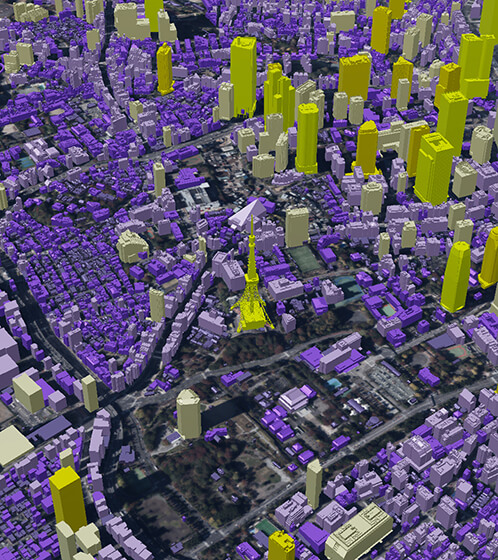
The value provided by 3D city models

Visualization (visibility)
Enables recognition of urban space in three dimensions, improving explanatory power and persuasiveness.
Simulation (reproducibility)
Reproduction of urban space with three-dimensional information on the cyber space enables a wide range of precise simulations.

Interactivity
Provides a platform for physical and cyber spaces to exchange information and interact with each other.
These values are combined to create a digital twin of the city and create new solutions.

The City Bureau of the Ministry of Land, Infrastructure, Transport and Tourism is promoting the digital transformation of urban development.
This section introduces the roadmap and key themes of PLATEAU, which will serve as the digital infrastructure for this digital transformation.
Timeline for 2030
2022
Extension of Standard Specifications
Dissemination of PLATEAU Standard 2.0 and development of 3.0
Establishment of data update scheme
Demonstration of data maintenance using various data sources
Support for data maintenance
Data development in about 100 cities nationwide
2023
Expansion of standard specifications
Study introduction of OGC CityGML3.0
Establishment of data update scheme
Establishment of a standard scheme based on demonstration results
Support for data development
Continue to develop urban data
2024 - 2027
Extension of standard specifications
Continue to study introduction of OGC CityGML3.0
Establish data update scheme
Establish short-cycle data update scheme
Support for data development
Data development in about 500 cities nationwide
2028 - 2030
Extension of standard specifications
Extension of PLATEAU standard to meet the needs of use cases, etc.
Establishment of data update scheme
Continue to establish short-cycle data update scheme
Support for data development
Further expansion of data development scope and social implementation
Project PLATEAU Road Map
2022 Main Theme
Project PLATEAU will promote the development and utilization of 3D city models and the creation of an open data ecosystem under the following three themes
Improvement of efficiency and sophistication of data maintenance
PLATEAU will further expand the existing standard specifications for 3D city models to incorporate new objects such as civil engineering structures, water surfaces, dynamic data, and point clouds. In addition, to improve the efficiency of data maintenance, we will develop automatic generation tools utilizing AI, etc., and make them available on the OSS.
Expansion, Densification, and Standardization of Data Specifications
Goal
- Extend the Japanese localized version of the standard specification (PLATEAU standard) based on OGC CityGML2.0 and expand the target objects to realize more sophisticated digital twin construction.
Action
- Demonstrate data creation of undefined objects and extend PLATEAU standard specifications based on this
- Improvement and dissemination of surveying manuals for efficient maintenance of 3D urban models
- Study of standard specifications for urban planning GIS to ensure compatibility between 3D urban models and urban planning GIS
Establish rules for modeling and surveying methods and update methods
Goal
- Establish technologies for efficient and low-cost maintenance of the 3D city model LOD2, thereby encouraging local governments to expand data maintenance.
Action
- Development of LOD2 automatic generation tool using AI etc. ‧OSS
- Establish a method for developing and updating 3D city models using various data sources such as crowdsourcing data, BIM models, and various ledger data held by local governments.

Development of advanced use cases
Demonstrate use case development of 3D city models utilizing advanced technologies in various fields such as disaster prevention, environment, urban planning, contents, and mobility, aiming to create best practices and deploy them nationwide.
Social implementation of use case development / formation of a private market
Goal
- Promote social implementation of use cases in various fields in the public and private sectors by demonstrating use case development of 3D city models utilizing advanced technologies, creating best practices, and promoting their horizontal deployment.
Action
- Development of use cases for solving social issues / Development of use cases for creating private sector services
- disaster prevention & crime prevention / environment & energy / urban planning & community development / regional revitalization / tourism & contents / mobility & robotics

Expanding Data Coverage
We will expand data coverage by utilizing the subsidy system for the development and utilization of 3D city models and open data by local governments, which will be newly launched in FY2022, etc. We will improve the data usage environment by renovating PLATEAU VIEW, developing open APIs and SDKs, and holding hackathons. Improvement of the data usage environment
To attract movement for data maintenance and utilization.
Goal
- Promote social implementation of 3D city models by supporting the development and utilization of 3D city models by local governments and the use of open data.
Action
- Support the development and utilization of 3D city models by local governments (Support project for the construction of a digital infrastructure for urban spatial information)
- Arrangement of legal issues to promote the use of open data, etc.
Provide ideas, knowledge, and technologies to support utilization
Goal
- To create an environment where various players in the public and private sectors can easily access and utilize data, thereby enhancing the capability of 3D urban models and creating open innovation.
Action
- PLATEAU VIEW modification to add new functions such as CMS
- Development of SDKs and other tools that can be used with Unity and other game engines
- Enhancement of technical tutorials, hackathons, etc.
![]()