| Showing road structure ranks on maps | |
|
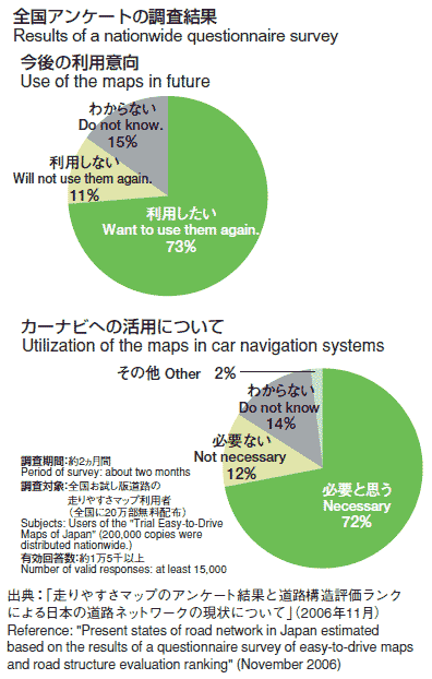
"Easy-to-Drive Maps" classify roads in terms of ease of driving for drivers, by such factors as road width and curves. The roads are classified into six ranks and are shown in different colors, line thick- ness, and numbers. Main accident blackspots and congested sections are also shown. Since the results of a questionnaire survey con- ducted in the prefectures of the Kyushu Area were promising, these easy-to-drive maps for the entire Kyushu Area started to be provided in March 2006. In September, the "Trial Easy-to-Drive Maps of Japan" were prepared, and approximately 200,000 copies were distributed throughout Japan. In a nationwide questionnaire survey of users, 70% answered they wanted to use the maps again and would like the maps to be installed in car navigation systems. | |

| |
| Easy-to-drive maps will be installed in car navigation systems | |
|
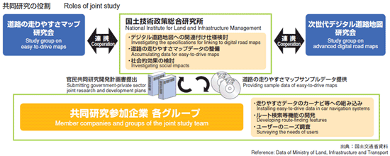
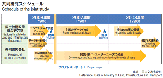
In December 2006, the National Institute for Land and Infrastructure Management and six groups of private companies (10 companies in total) started a "Joint study on using easy-to-drive maps in car navigation systems". In FY 2006 the Institute provided sample data of easy-to-drive maps to other members of the joint study team. The members then submitted a development schedule to the Institute and started studying ways to install the maps in car navigation systems by the end of FY2008. | |
|