
Land use
City Configuration
The most distinctive feature of the configuration is to place the urban center in the middle of the Research and Education District stretching 18km from north to south, between University of Tsukuba to the north and science and engineering research institutes to the south. Concentrating urban,housing,and research and educational functions in the middle of the city makes it possible to identify the nucleus of the city easily and to unify the whole scattered development area in an oblong shape.In addition, "the city's central axis", a space which symbolizes the new city, goes right through the university, the central district and research institutes. The axis is composed of a main pedestrian way, 6 public squares, and major urban facilities along the way. There is a network of walkways which separates pedestrians from automobile traffic. Facilities for the residents, like parks, schools, shopping centers, etc. are built along them and furnish pleasant and safe living space. Other characteristic aspects of the city include taking advantage of its rich natural environments such as existing forests and securing some land for the future projects such as the construction of a new transportation system and cultural facilities. An effort is being made to develop the Surrounding Suburban District into a broader urbanized region with the Research and Education District as its core.Land Use in the Research and Education District
Land in the Research and Educational District is divided into following 3 zones depending on how it is used.- (a) City Center Zone
- The City Center Zone is about 80ha, comparable in area to the Shinjuku sub-center of Tokyo. It is located in the middle of the Research and Education District, and is planned with features befitting to a city of 200,000 people. There are many facilities like the Tsukuba Center Building, the shopping center "CREO Square ","Q't",TX Tsukuba-Station, and Gakuen West Parking Building,that have already been constructed. Additional facilities for cultural events, administration, business, shopping and research exchange are being planned or under construction to develop the area as the true urban center.
- (b) Residential Zone
- The project housing area occupies about 25% of the residential zone (total 670ha), and is divided into 3 clusters, i.e. Hanamuro (Takezono, Azuma), Sasagi (Namiki) and Teshirogi (Matsushiro). The governmental housing for employees of research institutes and university (7,701 units) and public housing such as Urban Remaissance Agency.housing(2,829 units) were built in the area.
The rest 75% land for private houses and shops is also being developed,though its facilitation is key to the future population growth of the city. - (c) Research and Educational Facility Zone
- This zone is about 1,465ha, 54% of the Research and Education District. To facilitate research collaboration, thus to improve their research efficiency, 31 research and educational institutions are arranged according to their field of specialization; i.e. liberal arts and education, science and engineering, construction, biology, and common facilities.
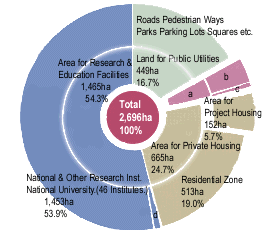 a: Community Facilities etc. (117ha 4.3%) b: Community Facilities (92ha 3.4%) c: Combination Business-Residence Facilities (25ha 0.9%) d: Private Research Inst. (12ha 0.4%) | 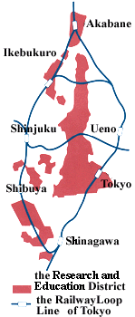 |
|
[Land Utilization Plan (Research & Education Distr.)] |
[Comparison of the Research and Education District with the Railway Loop Line of Tokyo] |