|
| Anti-flood
Control and River Improvement |
|
River projects develop fundamental
water control facilities of 13 important river systems including Ishikari
River and Tokachi River and the improvement and development of minor rivers
that suffered serious damage from floods in recent years.
Moreover, river projects promote the preservation and restoration
of precious waterside areas such as swamp areas registered with the Ramsar
Convention for the purpose of preservation the natural environment with
which Hokkaido is blessed. |
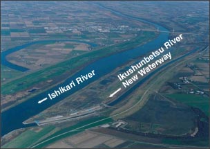 |
| Ikushunbetsu River
New Waterway Project |
|
| River Improvement Measures
for the Chitose River basin] |
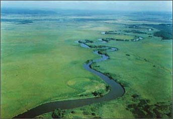
 Overview
of the Chitose River Basin Overview
of the Chitose River Basin |
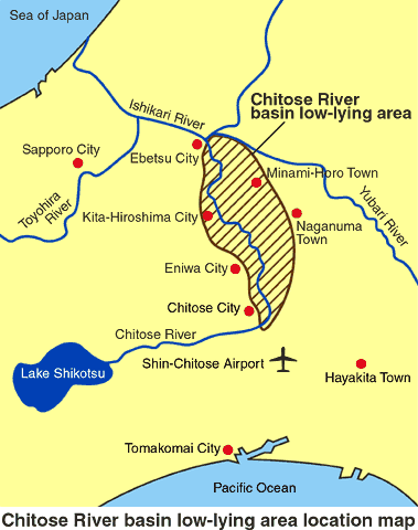
| Approximately 360,000 people live
in 4 cities and 2 towns in the Chitose River basin which is located beside
a tributary of the Ishikari River in the center of Hokkaido. Because of
the unique geological features of this valley - a vast area of flat lowland
spreading through the mid-lower region, during flood season the water level
of Ishikari River reaches a level of about 40km and continues at this level
in the Chitose River and Ishikari branch for a long period - it is an area
easily subject to flood damage. |
| An
overview of flood damage |
In the past, the Chitose River
basin has suffered flood damage at a frequency of about once in every two
years. The flood that occurred in early August 1981, caused flood damage
to about 2700 houses and around 20,000 hectares of land.
Although various measures have been taken to cope with flooding
in the past, until now thee have been no radical measures to cope with the
peculiar features of the Chitose River basin. |
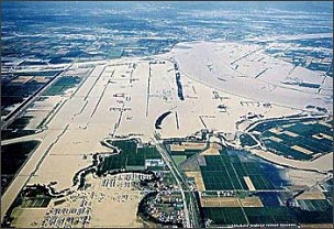 |
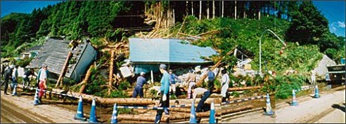
| 1981 Flood Damage
(Ishikari River) |
|
| River
Improvement Measures |
River improvement measures for
the Chitose River basin were proposed by a person of learning and experience
to the Chitose River basin total river improvement planning deliberation
committee and the bank (levee) strengthening (combining draining the basin)
proposal was submitted to the national government and Hokkaido in March
2002.
Based on this proposal, the government, Hokkaido and local self-governing
bodies created the Chitose River Basin River Improvement Measures Conference
consisting of organizations with interest concerns in the basin, and deliberations
dealing with improvement of the Chitose River basin began in July 2002,
and measures for strengthening levees to deal with inland water (combined
with drainage) and cooperation among local organizations in the area were
proposed.
With this as a start, a 30-year Chitose River development plan
targeting river development began in April 2005. Aiming at improving the
safety of the Chitose River basin, an important part of the development
plan, continuing priority projects such as dredging and digging river channels
and new levee building measure is being promoted. |
| [Preservation of Kushiro
Swamp] |
 |
| Kushiro Swamp and
Kushiro River |
|
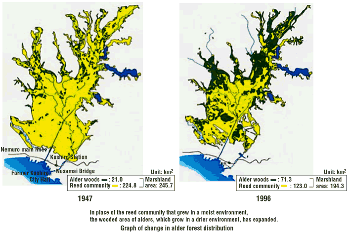
As the first registered Ramsar
Convention swamp in Japan and in connection with economic activity of the
basin, in recent years there has been rapid reduction of swamp are and a
marked change in vegetation in the Kushiro Swamp. A pressing issue is the
preservation and recovery of cherished wild life in the Kushiro Swamp, including
the Japanese crane and Northern salamander.
In September 1999, the Deliberation Committee for the Preservation
of the River Environment of Kushiro Swamp was established by a person of
learning and experience, related government agencies, etc., which compiled
a Proposal for the Preservation of the Kushiro Swamp in March 2001. Furthermore,
the Nature Recovery Promotion Law went into effect in January 2003 and based
on this law measures to promote the recovery of wild life in the area was
taken. |
With this background, in November
2003, the Kushiro Swamp Nature Preservation and Recovery Conference was
established for the purpose of recommending more effective methods for nature
reproduction than those undertaken up to that time. This conference combines
municipal corporation, related governmental agencies, and specialists, specially
invited local residents, NPO and NGO. In addition to strengthening cooperation
among the parties concerned, this organization promotes projects for various
subjects agreed upon by participating members.
In March 2005, a reproduction design for the entire Kushiro
Swamp area, which can be called a constitution, was decided upon to determine
the direction of the swamp preservation and recovery project. From this
point on, the Enforcement Plan based on the master plan is to be promoted
aggressively through the cooperation of the parties concerned. |
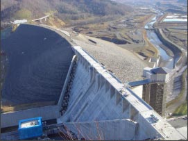 |
| Chubetsu Dam,
the main body of which is under construction |
|
This dam project is being conducted
for a safe, abundant and attractive improvement of the community and fulfills
a various roles:
| (1) |
Some of the flood water will be stored
in the dam and release of this water will be regulated to mitigate
down-stream flood damage. |
| (2) |
In times when there is a shortage of river
water, water is emitted from the dam to preserve the down-stream river
environment. |
| (3) |
Water from the dam supplies city water
and water for industrial use and irrigation. |
| (4) |
Water power generators use water flowing
from the dam |
Bibai Dam, a gateless system of improved dam construction for
efficient management. |
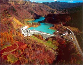 |
Bibai Dam,
a gateless system of improved dam
construction for efficient management. |
|
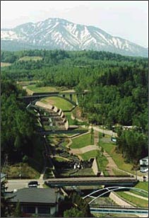
| Erosion control projects
and measures to prevent landslides on steep slopes |
There are 18 active volcanoes
in Hokkaido. At tourist resorts in volcanic areas, disasters caused by mud
slides and large-quantity sediment flow eruptions occur frequently.
On the other hand, urbanization is advancing around the foot
of mountains near cities, inviting an increase in danger of sediment disasters,
landslides and cliff slides.
For this reason, in areas where there are high emergencies,
preventing sediment flow emergencies is a serious matter to consider, advancing
erosion control projects to prevent landslides is urgent to promote a rich,
natural environment and improve the quality of life.
Moreover, this project advances development of disaster shelter
facilities in disaster areas where they can be available to persons in need
of help. |
 |
| Mt. Tokachi,
a volcano erosion control project |
|
Steep slope landslide measure
projects are undertaken concentrating on areas where there is concentration
of urgent high dangerous areas.
Green slope development is promoted to raises the degree of
safety by preserving and using existing tree and vegetation on slopes to
re-enforce and maintain a good natural environment and scenery. |
 |
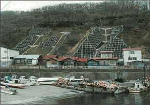
| Steep slope collapse
measure project (Hakodate City) |
|
Hokkaido being surrounded on all
four sides by the sea, the seashore is intimately connected with the lives
of Hokkaido people, as living space, a place for distribution and a production
activity, and a place for recreation.
For this reason, while coping with the damage and the remarkable
seashore erosion left by tsunamis, high tides, raging waves, in order to
lives comfortably with these natural phenomena and preserve and create a
congenial seashore environment, developing seashore preservation projects
needs to be promoted preponderantly and efficiently. |
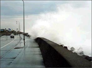 |
Overtopping
Waves Attacking
National Highway No. 36 (Shiraoi Bypass) |
|
 |
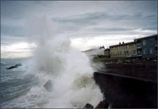 |
Backed by an
Adjoining Seawall and
Lined with Residences. |
|
|
| Direct
control seashore preservation facilities development project of Iburi seashore |
Although measures against erosion
using the line-protection method focusing on erect shore protection and
wave suppressing had been implemented along the Iburi seashore, because
100m-scale sand erosion advanced quickly and then disappeared after the
1965s, erect shore protection disappeared, wave suppressing subsided and
damage to residences by overtopping waves, began to recur.
For this reason, protecting unstable slopes along the shore
to reduce the amount of wave reflection and launching by making man-made
reefs to weaken the power of raging waves in the offing, and in places where
there is serious erosion, as needed making artificial beaches, since 1988
measures to prevent seashore erosion have been implemented with a field-protection
system combining every preservation facility needed. |
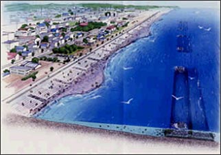 |
The image of
the field-protection
combining man-made reefs and
loose slope shore protection |
|
|
 |
| Sand recovered
by field-protection |
|
|
 |
| Soil saving
enterprise for recovering collapsed hillside (Shizunai-cho) |
|
Since the geology of a volcanic
eruption is widely distributed over the mountains of Hokkaido, such as Hokkaido
Mt. Komagatake, Mt. Tokachi, and Mt. Usu, there are about 24,000 high mountains
areas that are subject-to-disaster areas were there is danger of forestland
collapse under severe regional local rains, typhoons, and earthquakes.
While deliberately undertaking the soil-saving projects for
restoration development to prevent mountains disaster, mountains stripped
of vegetation, etc., in recent years, conditions of mountain disaster and
forest damage occur frequently because of typhoons and such. To ensure safe
and secure community improvement that is strongly resistant to disaster,
maintenance of the forest reserves is promoted.
Moreover, to secure good, stable water resources, in stream
source regions, dams or the upstream of small-scale water intake service
facilities, development of a desolated forest areas and development of a
water and soil preservation facilities are promoted.
Furthermore, in order to build a bountiful environment, while
advancing forest development as a place of relaxation for local residents,
forest develop which considers the scenery of the area and the habitation
environment of wildlife is carried out. |
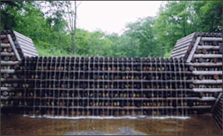 |
| Soil saving
dam utilizing thinning lumber (Toyokoro Town) |
|
|