Project PLATEAU | The Initiative of Digital Twin in Japan
#01
About PLATEAU
PLATEAU is a project led by Japan’ s Ministry of Land, Infrastructure, Transport and Tourism (MLIT) to develop, utilize, and open up access to 3D city models. Project mission is to create new value in society and solve local issues through the digital twin. This project involves partnerships with local governments, private companies, and tech communities.
3D city models of about 250 cities are provided as open data in the "G-Spatial Information Center" so far.


#02
Initiated in the Context of “Digital Transformation in Urban Planning,” PLATEAU Empowers Urban Resilience
PLATEAU aims to serve as a digital infrastructure for “Digital Transformation in Urban Planning,” which seeks to realize human-centered urban development that supports richer lifestyles and diverse ways of living and working through digital technology.
By building these models as platform data for urban activities, the project enables the development of diverse use cases across various sectors.


#03
The Value Provided by the 3D City Models in PLATEAU
PLATEAU’s 3D city models are described in a format based on the international standard CityGML. Unlike conventional 3D models that only capture “shapes,” they are digital twin implementation models in which objects such as buildings and roads are structured and enriched with “semantic” information — including details like usage, year of construction, and urban planning data.
PLATEAU’s 3D city models can be developed by “unearthing” and “reusing” existing resources such as survey reports and GIS data, which in the past had generally been restricted to internal use by government agencies. As a result, the 3D city models also serve as a means of creating new added value through the effective use of existing materials.
Furthermore, by establishing a development scheme that leverages resources commonly held by local goverments across the country, PLATEAU has enabled low-cost, scalable data development, which in turn has supported the rapid expansion of its coverage.
In March 2021, PLATEAU established Japan’s first standardized data model for 3D city models, the “Standard Data Product Specification for 3D City Models,” and has since continued to expand features and attributes, with the latest Version 5.0 now released.
By defining a standard data model, Japan has unified the specifications, formats, and quality requirements of 3D city models. This has enabled greater efficiency in software compatibility, sharing of development knowledge, and easier data integration, thereby making 3D city models open, stable, and user-friendly for everyone.

#04
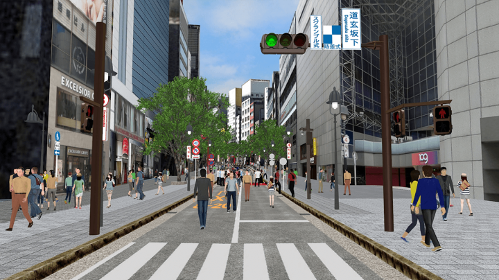
PLATEAU VIEW
PLATEAU VIEW is a browser-based web application that allows you to preview PLATEAU data.You can observe the city reproduced in digital space from any angle, and by freely overlaying layers of information in the space, you will be able to discover new perspectives that were not possible with previous data.

- ※ Required environment: CPU: Intel core i5, RAM: 16GB
- ※ Recommended environment: CPU: Intel core i7, RAM: 32GB
- ※ For details regarding the PLATEAU VIEW usage environment, please see here.

#05
Use Cases
PLATEAU’s 3D city models have the potential to address social issues and create new value. Across Japan, various solutions utilizing 3D city models are already being developed.
In diverse fields such as urban planning, disaster prevention, the environment, regional revitalization, and mobility, specialized companies and local governments collaborate to create use cases and conduct pilot projects in various cities, paving the way for future applications of 3D city models.
Urban Planning
Use in planning and simulation for urban planning, development and area management, consensus building, and in apps for the community.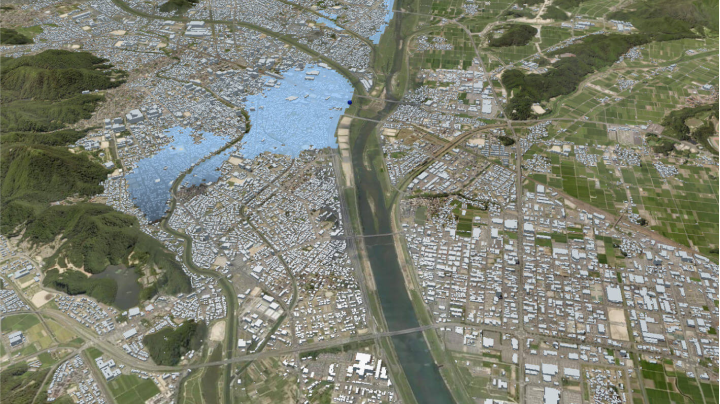
Disaster Management
Use in disaster prevention planning and simulation, risk visualisation, evacuation route apps, disaster prevention workshops.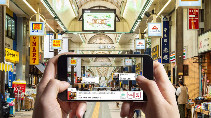
Revitalisation/Tourism
Used for creating metaverse spaces, XR tourism contents, tourism guide apps, advertising effectiveness simulations.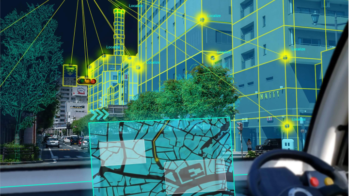
Mobility/Robots
Use for autonomous vehicles and drones for maps, OS and optimum route searches.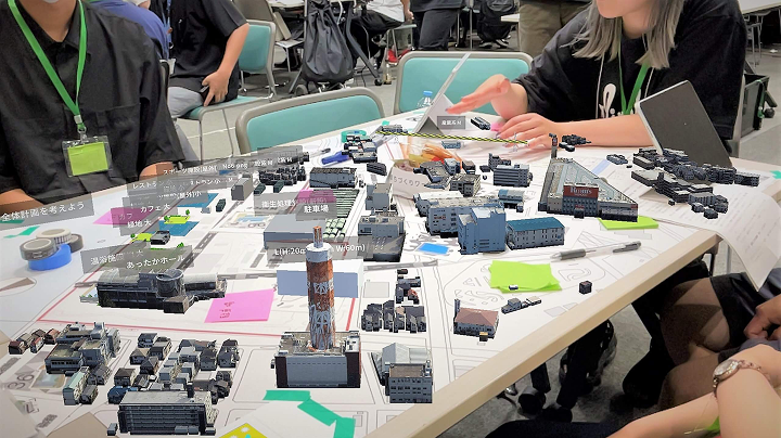
Public Participation
Use for apps, XR tools, dashboards to support public participation in urban development and local activities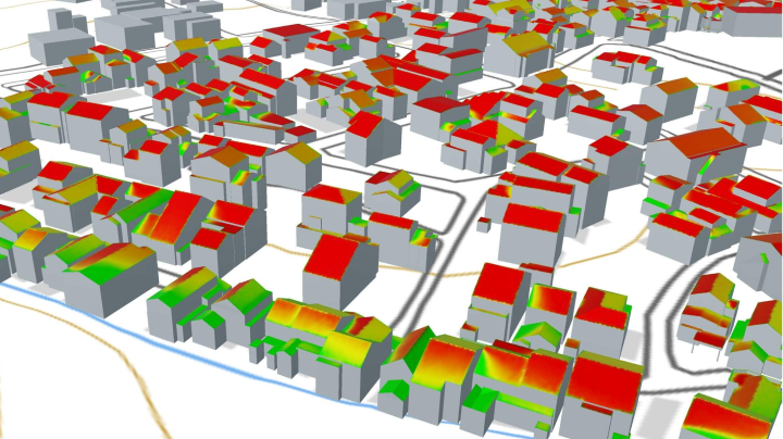
Environment/Energy
Use for simulation of solar power generation, heat islands, ventilation, and area energy management.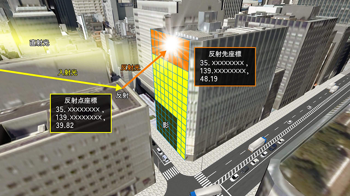
Infrastructure
Use for apps for buildings and park facilities management, ageing simulation and management through IoT data.
Digital Twin Tech
Development of technologies for segmentation and modelling of sensing data such as point clouds and integration with BIM.

#06
The Ecosystem that PLATEAU Strives to Build
The project aims to build an “ecosystem” in which the development, utilization, and open data release of 3D city models evolve autonomously.
Furthermore, by making urban data freely accessible to everyone, PLATEAU aims to foster open innovation.
Organizations from diverse backgrounds—including local governments, private companies, and local community—are actively participating in the PLATEAU community.
United by a common vision, they engage in ongoing discussions about the future of 3D city models and share insights to foster new use cases for their application.
