Technology
1. Pavement
In 1955, the paved road ratio of national highways in Japan was less than 14%.
The ratio increased sharply thereafter as motorization progressed rapidly, reaching 57% in 1965, 79% in 1975, and over 90% today.
Various paving technologies have been researched and developed since roads in Japan
are subjected to large seasonal temperature differences and heavy rainfall.
Technologies are also being developed to address an aging society and environmental issues.
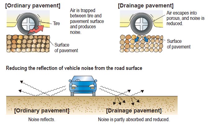
Drainage and low-noise pavement
The surface is more porous than ordinary pavement, allowing water to seep down through it. The water passes through the pavement and flows along an inclined impermeable course, and is then discharged to side gutters. The pavement drains well, remains non-slippery on the surface even on rainy days, controls spray, and ensures good visibility.
The porousness also suppresses the noise generated by tires and traffic.
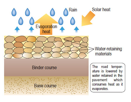
Water-retaining pavement
Water is retained in the pavement and the road temperature is lowered by the heat of water evaporation. Diverse technologies have been proposed, such as injecting water-retaining materials like polymers into the voids of asphalt mixtures, from which rain water and underground water slowly evaporate.
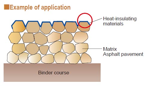
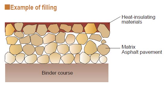
Heat-insulating pavement
Special paint is applied on the pavement surface to reflect infrared rays from the sun and thus reduce the heat which accumulates in the pavement. The paint controls the rise in surface temperature of pavement and improves the thermal environment for pedestrians and road-side areas, helping to mitigate the heat-island phenomenon.
2. Tunnels
The islands of Japan stretch out long and thin from north to south with a backbone of steep mountains rising to elevations of 2,000 to 3,000 m. As about 70% of the land is mountainous, roads must be constructed on the narrow strips of land between steep slopes and the sea, along rivers winding between mountains, and through tunnels.
Tunnels are increasingly used when constructing roads in highly populated areas of cities due to the shortage of land and to protect the environment.
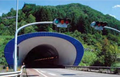
Kan-etsu Tunnel (Kan-etsu Expressway)
The Kan-etsu Tunnel passes through steep mountains with a maximum depth of 1,100 m from a mountain top.
Japan and the fifth-longest in the world. Of its four lanes, the outbound lanes were opened in 1985 and the inbound lanes were completed in 1991.
Yamate Tunnel (Central Circular Shinjuku Route of the Metropolitan Expressway)
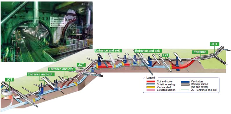
The Central Circular Shinjuku Route of the Metropolitan Expressway connects Shibuya, Shinjuku and Ikebukuro, which are major sub-centers of Tokyo. Two tunnels account for most of its 11 km length, one for the inbound lanes and the other for the outbound lanes.
The tunnels were completed in 2010.
Shield machine
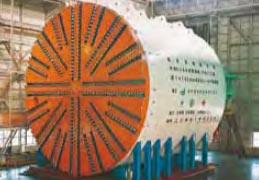
The shield machine cuts the ground with the cutter face in the front, assembles segments inside the machine, and advances through the ground by constructing the tunnel behind. Advanced robotic technologies are used, with a computer controlling the series of tunneling work.
3. Bridges
Japan consists of four major islands of Hokkaido, Honshu, Kyushu and Shikoku and a number of small islands.
Straits and inland seas hinder the traffic between islands.
For well-balanced development of the nation, new transportation axes are needed, and bridges connecting islands have been constructed.
Japan is also highly prone to earthquakes, typhoons and strong winds, so cutting-edge technologies are used for constructing and maintaining longspan bridges that can withstand such severe natural conditions.
Honshu-Shikoku Expressway
The Honshu-Shikoku Expressway, which was completed in 1999 and connects the main island of Honshu with the island of Shikoku, has three routes; the Kobe-Naruto route (the Kobe Naruto Expressway), the Kojima-Sakaide route (the Seto-Chuo Expressway and the JR Seto-Ohashi line), the Onomichi-Imabari route (the Nishi-Seto Expressway).
Control length of these roads is approximately 173 km.
The center span of the Akashi Kaikyo Bridge is 1,991m; the longest in the world, and the height of the main tower is approximately 300m above sea level.

Tokyo Bay Aqua-line Expressway
Of the 15.1 km of the Tokyo Bay Aqua-line Expressway across Tokyo Bay, which was completed in 1997, about 10 km is a tunnel under the ocean and the remaining 5 km is a bridge (Aqua Bridge). A ventilation tower ("Kaze-no-to") was constructed in the middle of the tunnel, and a manmade island ("Umihotaru") was constructed where the tunnel and the bridge meet.
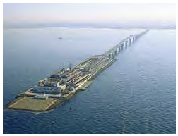
A manmade island "Umihotaru" and the Aqua-line Bridge
4. ITS
In Japan, ITS (Intelligent Transport Systems) are steadily expanding with the popularization of ETC (Electronic Toll Collection System) and VICS (Vehicle Information and Communication System), and have effectively opened up traffic by providing real-time information; eliminating congestion at toll gates; and mitigating environmental impacts by differential toll discounts. ITS has now entered its second stage and is being promoted in order to solve social issues.
Installation of systems for collecting and providing information, which are the basis of ITS, is promoted and systems are being developed whereby drivers can enjoy diverse services via a single ITS on-board unit.
ETC (Electronic Toll Collection System)
Since it went into service in March 2001, ETC users have been rapidly increasing in number with the quick popularization of ETC on-board units. At the end of March 2011, there were about 34.24 million ETC-equipped vehicles. ETC users now account for 86.2% of all vehicles on expressways in Japan.
The system has effectively eliminated congestion at toll gates.
Previously, 30% of congestion on expressways occurred at toll gates. By allowing drivers to pass through toll gates without having to stop, ETC improves the processing capability of toll gates, eliminating congestion that would otherwise occur there.
ETC communication technology is also used by private opera tors for non-stop passage through parking gates and ferry boarding, among others.
Changes in number of vehicles equipped with ETC on-board unit and percentage of ETC use
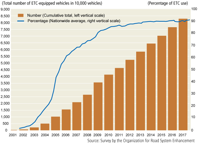
Source: Survey by the Organization for Road System Enhancement
Congestion reduction effect of spreading ETC use on Metropolitan Expressway
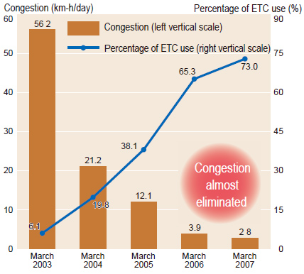
Percentage of ETC use and congestion show March weekday averages at main-lane toll booths.
Source: Metropolitan Expressway data
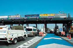
ETC for non-stop toll collection has been installed at almost all expressway toll gates in Japan, contributing toward mitigating toll-booth congestion.
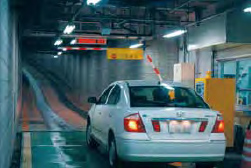
Automated parking lot payment
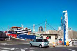
Simplified ferry boarding procedure
VICS (Vehicle Information and Communication System)
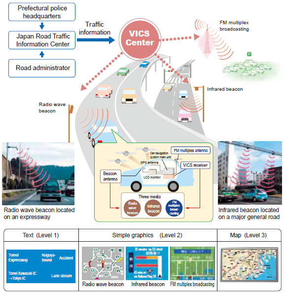
VICS transmits road traffic data, such as congestion and traffic restrictions on a real-time basis, to onboard vehicle navigation units and displays data in the form of text, simple graphics and maps.
The service started in Japan in April 1996, earlier than anywhere else in the world. VICS delivers information using three types of media: FM multiplex broadcasting, a radio wave beacon and an infrared beacon.
At the end of March 2011, over 30.13 million vehicles were equipped with VICS compatible onboard units. VICS's best route guidance rectifies traffic flow and improves mileage, which in turn reduces CO2 emissions and environmental impacts.
A target of the Kyoto Protocol Goal Achievement Plan is to reduce CO2 emissions by approximately 2.5 million tons (approximately 30% of all road related policy measures) by FY 2012. through the popularization of VICS.
Number of VICS-compatible on-board units in use
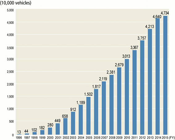
Prepared by MLIT based on VICS's data
Mechanism of VICS information
5.Deployment of Multiple Applications via Smartway
“Smartway” is a next-generation road traffic system incorporating ITS technologies, which provides information to
connect people, vehicles, and roads, with the primary aim of ensuring traffic safety, reducing traffic congestion, and
protecting the environment. To make this concept a reality, industry, government, and academia have been working
together in research, development, and demonstration testing.
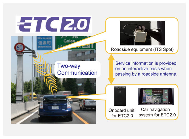
In 2011, we started the world’s first Vehicle-to-Infrastructure (V2I) communication service, which enables high-speed
high-volume two-way communication between automobiles’ onboard units and ITS spots, was installed along
expressways across the country.
Other new services are scheduled to start in the future.
System Architecture
This system uses 5.8 GHz DSRC (Dedicated Short Range Communication), an international standard adopted by ISO (International Organization for Standardization) and ITU (International Telecommunication Union) that enables high-speed, high-volume, two-way communication. DSRC will make various services available by using roadside equipment, “ITS spots”, and “compatible in-vehicle car navigation systems.”
Expanding ITS spot services throughout Japan
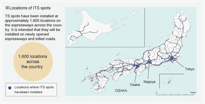
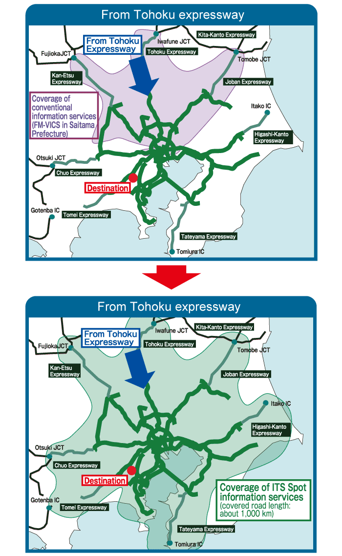
As of August 2011, ITS spot services are available in about 1,600 locations positioned on expressways throughout Japan. On inter-city expressways, an ITS spot is installed about every 10 to 15 km, including 90 locations immedi ately in front of junctions, while on urban expressways there is a spot installed about every 4 km.
ETC2.0 Service
Comparison of the scope of information that is provided by existing FM-VICS and ITS spots (Urban areas)
Since October 2014, we begun a new service called
“ETC2.0”, which provides advanced driver assistance
on expressways using the communication between ITS
spots and onboard units, and adds to the existing auto
matic toll payment feature.
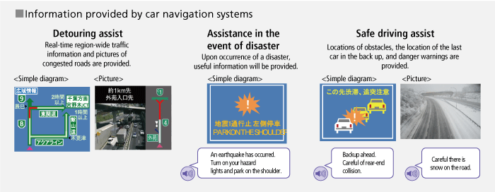
ETC2.0 provides the following assistance services:
(1) Traffic avoidance: provides precise information about
wide-area traffic congestion on a real-time basis with
actual pictures of the road ahead of the driver.
(2) Safe driving: provides safety precautions, such as iden
tification of obstacles on roads, a slow-running automo
bile at the end of congestion, and pictures of the
weather condition ahead of the driver.
(3) Driving during a natural disaster: provides useful infor
mation for drivers in the event of road closures.
Enhanced services for ITS spots
In the future, new ETC2.0 services are scheduled to begin. Drivers will soon be given preferential treatment if they take a detour around congested routes. In the future we are also going to support commer cial fleet control through ETC2.0. Furthermore, private services such as automatic payment systems at private parking lots and drive-through booths are under consideration.
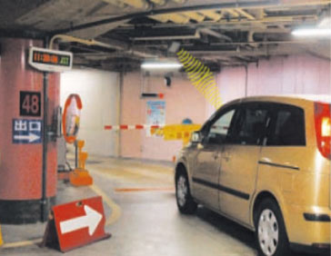
Automatic payment system at a parking lot.
6. Environmental Measures
Projects are being executed to quickly improve roadside environments and roadside areas.
In order to prevent global warming, the transport industry must urgently deploy measures to reduce CO2 emissions from vehicles, which account for a large percentage of total emissions.
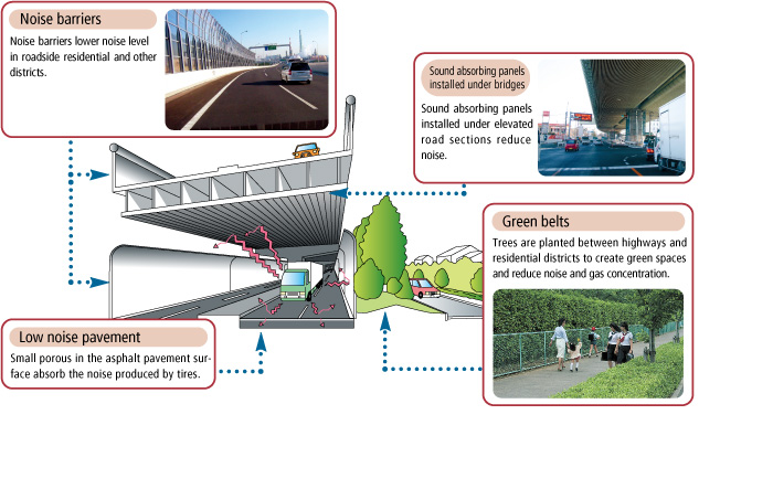
Protecting and creating roadside environme
Roadside environmental measures are being deployed to achieve environmental quality standards on noise and air pollution.
Measures to control the heat-island phenomenon in cities are also being actively researched and developed.
Implementation of road measures that contribute to reduced CO2 emissions
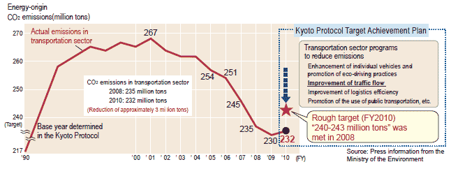
According to Japan's Kyoto Protocol Target Achievement Plan, reduction targets are decided for each sector.
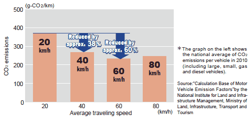
By FY2010 the transportation sector needs to reduce emissions by 14-17 million tons from the actual emission level of FY2005. Since the increased traveling speed resulting from smooth traffic flow improves effective mileage and thus reduces CO emissions from vehicles, traffic flow improvement measures are under way, including improvement of ring road and arterial road networks, grade separation of intersections, as well as the development of the cycling environments and the advancement of ITS.
Changes in CO2 emissions in transportation sector
Traveling speed and CO2 emissions
7. Efficient Operation of the Road Network
Traffic is controlled 24 hours a day to insure efficient operation and to provide safe, smooth and comfortable traffic flow. Diverse kinds of road information are collected, accumulated, analyzed and provided to road users.
Collecting information
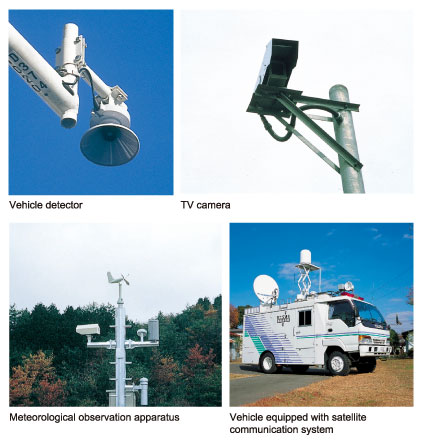
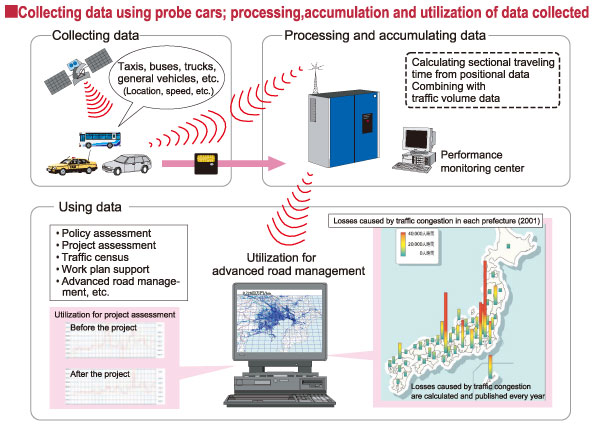
Vehicle detectors, TV cameras, meteorological observation apparatuses and other sensors are installed along roads to quickly collect correct information on traffic congestion, stationary vehicles, and accidents. During disaster events, patrol cars and vehicles equipped with satellite communication systems rush to the site and collect information. Today, efficient methods are used to identify congestion-prone points, such as the use of GPS equipped probe cars, VICS data and other ITS technologies, in cooperation with police departments, instead of the conventional method of conducting field surveys at major intersections.
