Sasago Tunnel Ceiling Collapse on the Chuo Expressway (PDF)
The Maintenance of National Road Network in Japan (PDF)
Maintenance
II. Management and search features for GIS records
Easy-to-use search system for management/inspection result records that meets needs of administrator]
nfraDoctor provides a customizable search system for management/inspection result records depending on the need of infrastructure administrator. This solution helps realize rational and efficient management.
Maintenance and management work involves record data for structures, accessories, and underground utilities. InfraDoctor provides efficient management by associating record data with 3D point group data.
III. Further sophisticated management and advanced features
Further sophisticated infrastructure management through expanded features using GIS and 3D point group data
InfraDoctor provides various features, including drawing, deformation detection on pavement and walls, creation of safety restriction drawing and 3D simulation, streamlining maintenance work through a good use of GIS and 3D point group data.
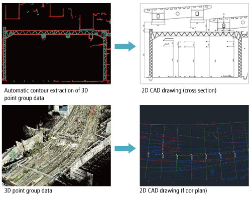
InfraDoctor provides a semi-automatic feature of drawing floor plan/cross section from 3D point group data. InfraDoctor also provides a high measurement resolution with mm for cross section and sufficient resolution for a 500:1 scale floor plan.
InfraDoctor provides a semi-automatic feature of creating a 3D CAD model from 3D point group data that reflects the current condition of structure.
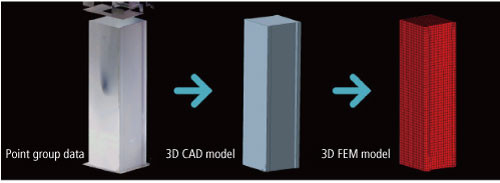
Creation of an FEM model from 3D point group data
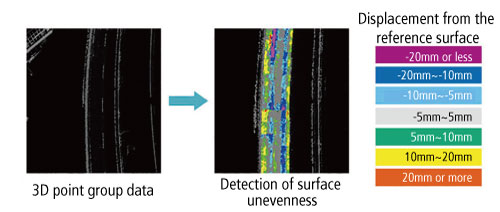
InfraDoctor creates a reference surface from 3D point group data of surface and structures, displaying a difference from the 3D point group data with gradient tints. This feature enables an early detection of ruttings, potholes, concrete jacking and damage from delamination, serving as a preliminary investigation before detailed inspection (close investigation).