
Country Profile
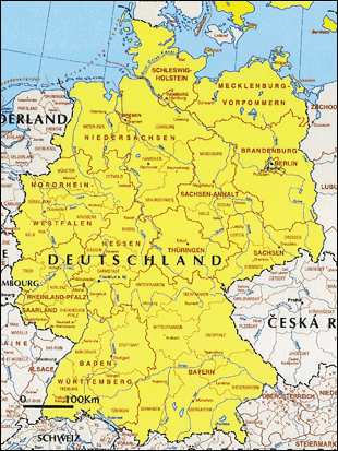
The territory of Germany is approximately the same size as that of Japan and extends from the North Sea and the Baltic in the north to the Alps in the south. The population of 80 million is the largest among the EU member countries, while the total fertility rate, comparable to that of Japan, remains low compared with other EU countries. (TFR 1.33, 2006)
After the Second World War, Germany was divided into the German Federal Republic (West) and the German Democratic Republic (East). The Berlin Wall fell in November 9, 1989 and Germany was reunited in October 3, 1990. Reduction of disparities between the East and the West is being sought in addition to changes that include improvement of the high-speed rail networks, taking into consideration the levels of infrastructure in East European and other European countries. The outflow of population from the former East German states has been prominent in recent years.
TableGermany fast facts
| Country name | Federal Republic of Germany |
|---|---|
| Surface area | 357,000 km² (approximately 94% of Japan) |
| Population | 81.77 million (2015: Federal Statistical Office) |
| Population density | 229/km² |
| Percentage of urban population | 75.3% (2015) |
| GDP (real) | EUR 2,576 billion (2010) EUR 2,669 billion (2011) EUR 2,679 billion (2012) EUR 2,682 billion (2013) EUR 2,725 billion (2014) EUR 2,783 billion (2015) (Federal Statistical Office) |
| GDP per capita (nominal) | EUR 31,511 (2010), EUR 33,005 (2011) EUR 33,569 (2012), EUR 34,219 (2013) EUR 35,230 (2014) (Federal Statistical Office) |
| Percentage of employment by industry | agriculture: 0.6% industtry: 30.3% sevices: 69.1% (2016 est.) |
| GDP growth rate (real) | 4.1% (2010), 3.6% (2011), 0.4% (2012) 0.1% (2013), 1.6% (2014), 1.7% (2015) (Federal Statistical Office) |
(Information Updated: March 2017)
Local Governments and Spatial Planning System
Under the federal system, the authorities of the federal and state governments are defined by the Basic Law for the Federal Republic of Germany (Grundgesetz für die Bundesrepublik Deutschland). The States have certain authorities and their own laws concerning spatial planning. At the same time, there also are detailed provision on inter-governmental exchange of information, participation, consent, collaboration and obligations.
Table:Government Organizations
| Government | Number | Spatial plan | |
|---|---|---|---|
| Federal Government | 1 | None except guidelines | |
| Federal states (Bundesländer) |
Area states (Flächenstaaten) | 13 | Plan based on Spatial Planning Act |
| City states (Stadtstaaten) | 3 | F Plan | |
| Districts | Rural districts (Landkreise) | 201 | |
| Urban districts (Kreisfreie Städte) | 112 | ||
| Municipalities (Gemainde) | 12,227 | F Plan, B Plan | |
Major Authorities Relating to Spatial Policy
| Administrative Area | Authority | Web Site | |
|---|---|---|---|
| Infrastructure, urban affairs | Federal Ministry of Transport and Degital Infrastructure | http://www.bmvi.de/EN/Home/home_node.html | |
| Spatial plan | Federal Office for Building and Regional Planning | http://www.bbr.bund.de/BBR/EN/Home/home_node.html | |
| Regional policies | Federal Ministry of Economic Affairs and Energy | http://www.bmwi.de/Navigation/EN/Home/home.html | |
As concerns spatial planning, Germany has been attempting regional planning since the early 20th century to address urbanization, including centralized spatial planning under the Nazi regime. A spatial planning system was put in place after the War in the 1960s, but the amendment of Basic Law for the Federal Republic of Germany in 2006 brought about exclusion of federal framework legislation, the system which in its areas spatial plan was included and that requires the states to align with the framework set out by the federal government when they work out details. Thus spatial plan was replaced into the areas of concurrent legislation, the system that enables the states to exercise their power in case the federal government does not exercise the power of legislation. In fact, the federal government is going no further than to set forth overall guideline while the states manage individual spatial plan based on the Spatial Planning Act.
As regards regional policies, the improvement of regional economic structures is positioned by the Constitution as a joint operation wherein the federal government is required to collaborate with the state government and bear half of the costs. Emphasis has been placed on providing assistance to the former East German regions after the unification of East and West Germany.
Spatial Planning
- Role of Federal Government
- At the federal level, in 1965 the Federal Spatial Planning Act was enacted, setting out an institutional framework of procedures of spatial planning. In 1967 the Ministerial Conference for Regional Planning (MKRO: Ministerkonferenz für Raumordnung) was established, for the purpose of inter-governmental coordination on planning issues as well as for the establishment of basic concepts regarding spatial planning. The significant revision of the Federal Spatial Planning Act in 2008 enabled the federal government to establish spatial plan, however such planning has only been carried out for EEZ.
- Spatial Development Concept and Strategy in Germany
- The "Spatial Development Concept and Strategy in Germany (2006)," the latest policy document concerning federal spatial planning, takes sustainability, European dimension and the like into consideration, and is placing emphasis on three areas: i) achieving growth and innovation, ii) ensuring public services, iii) conserving resources, and preserving and nurturing cultural landscape.
- State Spatial Planning
- In accordance with Articles 8 through 16 of the Federal Spatial Planning Act, state governments individually establish Wide-area Plan for State Area (state-wide area plan) for the whole state and Wide-area Plans for Partial Areas of State (regional plan) for some particular part of the state. Regional plans have now been established in 104 regions throughout the whole federation.
- Relationship between Spatial Plans and Other Major Planning Systems
- While spatial plans are being implemented in alignment with other related plans, there also are regions that are utilizing the F Plan as a comprehensive plan.
| Urban planning | Based on the Federal Construction Law (1960), as well as the Code of Construction (1986), basic autonomous bodies in all states formulate a F Plan (outlines land use and is binding on the administrative authority formulating the Plan; scale of about 1:10,000) and a B Plan (a construction guidance plan that is binding also on the actions of private individuals; scale of about 1:500). The federal Spatial Planning Act requires that F and B Plans be in conformity with the regional plans. |
|---|---|
| Agricultural land, etc. | Along with F Plan encompassing the entire autonomous body including agricultural land and the like, Landscape Plan (L Plan) and Green Structure Plan (G Plan) are also established from the view of natural use of land including agricultural use. The plans are in consistency with each other. |
| Development of infrastructure | A Federal Transit Plan, which is coordinated with the spatial plans, is formulated for key infrastructure. |
Figure:Metropolis, the upper and middle centers with central regions
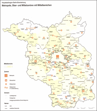
Source:National Development Plan Berlin-Brandenburg 2009/3
- Metropolitan Planning
- Metropolitan planning varies greatly by state.
- The city state of Berlin and the state of Brandenburg, which surrounds Berlin, have entered into a two-state comprehensive agreement for spatial planning, which has resulted in the "Berlin-Brandenburg Joint Comprehensive Spatial Development Plan". (The Berlin-Bonn Act was enacted in 1994 as the basic law coverning the transfer of capital functions.)
- Further, the spatial plan of the state also functions as the F Plan for the three cities of Berlin, Bremen and Hamburg comprising a single metropolitan area, and there are progressive cases like Frankfurt, where a city formulates an F Plan as a metropolitan area in collaboration with other neighboring cities. However, generally speaking, major cities and neighboring municipalities often formulate an F Plan individually, form various regional associations or similar groups, and formulate metropolitan plans in terms of said groups.
Improvement of Regional Economic Structures
The regional policies of the former West Germany have evolved from the post-War reconstruction to the promotion of economic development mainly in agricultural areas and the revitalization of declining industrial areas. The amendment of the Basic Law in 1969 resulted in a framework requiring the federal government to cooperate with the state government and to provide financial assistance for the improvement of regional economic structures. The federal government has been providing direct and indirect assistance, establishing the framework encompassing such factors as the region subject to assistance, the overall objectives, and the type of annual financial assistance granted to each state. Implementation is left to the states. Following the unification of the East and the West, emphasis has been on assistance to the former East German states. Recent development includes the determination on January 1, 2007 of regions subject to assistance for the 2006-2013 period, which corresponds to the period covered by the EU's regional policy.
EU regional policy: For the period 2014-2020, seven states are classified as "transition regions" (encompassing about 18.5% of the population). ("transition regions" whose GDP per capita is 75% up to less than 90% of the average of 27 EU countries, See the page on EU for details on "transition regions")
- Wide-area Plan for State Area (state-wide area plan)
- ein Raumordnungsplan für das Landesgebiet (landesweiter Raumordnungsplan)
- and
- Wide-area Plans for Partial Areas of State (regional plan)
- Raumordnungspläne für die Teilräume der Länder (Regionalpläne)
(Information Updated: March 2011)