
Country Profile
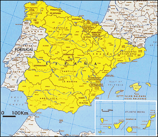
Located on the Iberia Peninsula, Spain borders the Mediterranean Sea on the southeast, the Atlantic Ocean on the northwest, and France on the north via the Pyrenees Mountains. Its population of approximately 47 million (2011) accounts for approximately 10% that of the EU. Within the EU, it ranks fifth in population following Germany, France, United Kingdom, and Italy.
Madrid, its capital, has the second largest population as a European city after Berlin and third largest as a metropolitan area after Paris and London.
TableSpain fast facts
| Country name | Kingdom of Spain |
|---|---|
| Surface area | 506,000 km² (about 1.4 times that of Japan) |
| Population | Approximately 46.46 million (2016.7) |
| Population density | 92/km² |
| Percentage of urban population | 79.6% (2015) |
| GDP | USD 11,997 billion (2015: IMF) |
| GDP per capita | USD 25,843 (2015: IMF) |
| Percentage of employment by industry | agriculture: 2.5% industry: 22.4% services: 75.1% (2016 est.) |
| Economic growth rate | ▲1.0% (2011), ▲2.6% (2012), ▲1.7% (2013) 1.4% (2014), 3.2% (2015) (IMF) |
(Information Updated: March 2017)
Local Governments
The fall of Franco's Regime in 1975 was followed by the official announcement of the new Constitution in 1978. The Constitution of 1978 created autonomous regions (Comunidades Autónomas) as new administrative bodies in addition to the existing local bodies, such as municipalities (Municipio) and provinces (Provincia), and transferred the authorities relating to city and regional planning and housing development from the central government to the autonomous regions. Spain currently has 17 automonous regions, 50 provinces, and 8112 municipalities under the central government. The Constitution also provides for associations of municipalities (Mancomunidades de Municipios), counties (Comarca), metropolitan areas (Área Metropolitana), and the like as administrative bodies that may be formed arbitrarily.
62% of Spain's population is concentrated in 68 cities, which account for only 6% of the total number of municipalities and 7% of the national land. Furthermore, 90% or more of the autonomous regions, which account for 27% of the total population and 84% of the national land, are small municipalities with a population of 10,000 or less.
Major Authorities Relating to Spatial Policy
| Policy Area | Authority | Web Site | |
|---|---|---|---|
| Central Government | Infrastructure | Ministry of Development: Ministerio de Fomento |
http://www.fomento.gob.es/ |
| EU regional policy | Ministry of Economy and Finance: Ministerio de Economía y Hacienda |
http://www.minhap.gob.es/ | |
| Regional policies of local governments | Madrid Autonomous Region: Comunidad de Madrid |
http://www.madrid.org/cs/Satellite? pagename=ComunidadMadrid/Home |
|
| Catalunya Autonomous Region: Generalitat de Catalunya |
http://www.gencat.cat/ | ||
| Barcelona Metropolitan Area: Àrea Metropolitana de Barcelona |
http://www.amb.cat/web/guest | ||
The concentration of population in urban areas and the large number of small agricultural communities can be pointed out as the major characteristics of the urbanization of Spanish cities. The seven major cities, comprising of those with individual population of more than 500,000 - specifically Madrid (about 3.21 million), Barcelona (about 1.61 million), Valencia (about 800,000), Sevilla (about 700,000), Zaragoza (about 660,000), Malaga (about 570,000) - and Bilbao (about 350,000), have formed metropolitan areas by absorbing multiple neighboring autonomous bodies, and approximately 34% of the total population are concentrated in those seven metropolitan areas. The rectification of the concentration of population in the metropolitan areas has been recognized as a policy issue since after the civil war in the 1940s, and metropolitan policies for the formation of competitive regions within Europe are still being sought.
In the meantime, the problem of imbalance within the country and within regions is also being recognized. Torn between domestic decentralization and the strengthening of EU policies, Spain is seeking spatial policy that involves collaboration among the EU, the country, and the country's regions in order to achieve sustainable use of national land.
Major Present-Day Tools Relating to Spatial Planning
Table:Major Spatial and Regional Improvement Plans
| Plan | Authority |
|---|---|
| Territorial General Plan (PTG) | Autonomous region |
| Territorial Planning Guidelines (DOT) | Autonomous region |
| Provincial Territorial Plan (PTP) | Autonomous region |
| Sectoral Territorial Plan (PTS) | Autonomous region |
| General Plan for Metropolitan Areas (PGM) | Municipality as a general rule; may be formulated by a group of multiple municipalities |
| General Plan for Urban Zoning (PGOU) |
What corresponds to Japan's City Planning Act is the Land Act (Ley del Suelo). Enacted as the first comprehensive city planning system in 1956, it was subsequently amended in 1975, 1990, 1998, and 2007. The current Act exists as succinct principles, and the actual implementation of land policies and city plans are left to local bodies in autonomous regions.
- Territorial Spatial Improvement System
- The Land Act, first amended in 1975, introduced the National Plant (Plan Nacional) devised by the country and the Territorial Coordination Guidance Plan (Plan Director Territorial de Coordinaión) devised by regional authority covering a broader area.
- However, a national spatial plan has never been formulated in the past, and the Territorial Coordination Guidance Plan was also replaced by the Territorial Improvement Guidelines required by each region pursuant to the Local Autonomy Act under the new Constitution of 1978 (Directrices de Ordenación Territorial: Basque Region, Aragon Region, etc.) or the General Territorial Plan (Plan Territorial General: Catalunya Region, etc.). These plans encompass not only spatial plans, but also regional socio-economic plans.
- Development of Territorial City Plans through Collaboration of Multiple Municipalities
- Meanwhile, municiplalities, which formulate plans pursuant to the Land Act as basic autonomous bodies, may work together to prepare a single plan when the metropolitan area covers multiple municipalities in reality. The General Plan for Barcelona shown below is a typical example.
Relationship with EU's Measures
The EU has substantial influence on regional development policies, and Spain has been receiving the significant aid from the EU's Structural Fund over the last 15 years. There has been a relative decrease in the amount of aid from the Fund following the accession of East European countries. The country's central government is currently making efforts to negotiate and coordinate with Europe, as well as coordinate with its autonomous regions.
There also are cases, such as in the Castilla La Mancha Region, where ESDP is positioned for practucal purposes as the higher level regional spatial plan that indicates a superior vision, even though it does not have a binding effect.
Figure:General Plan for Barcelona Metropolitan Area
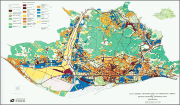
Source: Àrea Meetropolitana de Barcelona (1999) "La construcció del territori metropolità"
Spatial Planning in Barcelona Metropolitan Area
The General Plan for Barcelona Metropolitan Area (Plan General Metropolitano de Barcelona; PGM) formulated in 1976 covered the Barcelona Metropolitan Area comprising 28 municipalities (surface area of approximately 476km², and a populantion of about 3.1 million at the time). The General Plan is still valid as a territorial master plan for coordinating the spatial plans of large territories within the framework of the "metropolitan area."
Regional Spatial Planning
All autonomous regions have now completed the enactment of regional development laws. The objectives of the regional development plans established by the autonomous regions generally are the i) promotion of balanced regional development, ii) improvement of the quality of life, and iii) preservation of environment and resources important to the region.
- Madrid Region Spatial Strategic Plan
- This plan, which was formulated in 1997, seeks to achieve the integral preservation of green areas through improvement of access between the densely populated areas, which are mainly inner-city areas, and other areas within the region.
- Catalunya Territorial General Plan
- The Plan was formulated in 1995 to achieve territorial balance by correcting the over-concentration of population in Barcelona and inducing development plans. Since future visions vary by territory, Catalunya divided the region into seven planning units and presented 15 indices (preservation of landscape and scenery, improvement of transportation network, etc.) for the formulation of the plan.
(Information Updated: March 2010)