
Country Profile
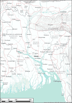
Bangladesh is located at the innermost part of Bay of Bengal, Indian Ocean, and it is at the downstream or otherwise the mouth of large rivers such as Padma (Ganges in upstream territory in India), Jamuna and Meghna Rivers, with about 50% of its national land below 6-7meters above sea level and about 68% of the surface is exposed to the risk of flood and soil erosion. It shares border with India at three sides of the country and a part of its southeast border is shared with Myanmar.
The country became independent as a part of Pakistan in 1947 and later it gained independent as Bangladesh in 1971. Out of its population of 150 million, about 90% is Muslim, but there are Hindu, Buddhist and Christian as well.
Bangladesh was once regarded as one of the poorest countries but it is setting a goal of becoming a middle-income country by 2021, which is the 50 years of independence, and is recently maintaining high annual GDP growth around 6%. On the other hand, Bangladesh is facing the challenges of sophisticating industrial structure in response to rapid increase of urban population and its enormous number of population.
TableNational Statistics
| Country name | People's Republic of Bangladesh |
|---|---|
| Surface area | 147 thousand km² (about 40 % of that of Japan) |
| Population | About 159.4 million (March 2015: Bangladesh Bureau of Statistics) |
| Population density | 1,107/km² |
| Percentage of urban population | 34.3% (2015) |
| GDP | USD 156.6 billion (2015: IMF) |
| GDP per capita | USD 1,385 (2016: Bangladesh Bureau of Statistics) |
| Percentage of employment by industry | agriculture: 15.1% industry: 28.6% services: 56.3% (2016 est.) |
| GDP growth | 7.11% (2016: Bangladesh Bureau of Statistics) |
(Information Updated: March 2017)
FigureTopography of Bangladesh
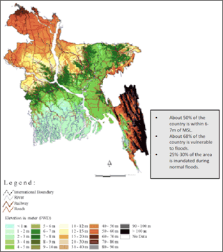
Source: Disaster Management Bureau, Disaster Management & Relief Division, National Plan for Disaster Management 2010-2015, April 2010
Local Administration System of Bangladesh
Basic administrative districts of Bangladesh consist of Division, District (Zilla/Zila) and Sub-district (Upazilla/Thana; hereinafter referred as Upazilla). Under those, there are; Union in rural areas and City Corporation or General City (Pourashava) in urban areas. It is stipulated in Article 59, Paragraph (1) of the Constitution of People's Republic of Bangladesh that “local government in every administrative unit of the Republic shall be entrusted to bodies, composed of persons elected in accordance with law”. However, direct election is implemented only for Union parliament and mayor and parliament of City Corporation and General City (Pourashava).
FigureLocal Administration System of Bangladesh
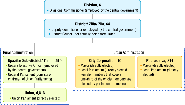
- *None of the local administration body has an authority to enact ordinances.
- *In Chittagong area, with consideration for ethnic minorities, number of seats is allocated with respect to each ethnic group.
Source: Table created referring to; Takuro AWAZU, “Research on basic legal structure of Bangladesh”, Ministry of Justice, Government of Japan, Feb. 28 2014. (Except for number of each local government, which was taken from school textbook of Bangladesh “Civics and Citizenship” (Class 9-10).)
Organ(s) in charge of national spatial policy
| Name and the policy area of the plan/policy | Name | Web site |
|---|---|---|
| Planning Commission | General Economics Division (GED) 〔Planning Commission is a commission headed by prime minister which gives final approval to the national plans of highest levels such as Five-Year Plan. GED is the secretariat of the commission.〕 |
http://en.banglapedia.org/index.php?title=Planning_Commission |
Plans and policies for territorial/regional development
General nationwide territorial plans are as follows. These are more like economic plans but they include explanations on infrastructure development, etc.
Vision 2021 is the document which Bangladesh Awami League, the current administration, have prepared as a manifest in advance of general election in 2008. It includes goals such as “making Bangladesh a middle-income country until 2021 (50 years of independence)”, and although it isn't a governmental document, the policies of the vision are reflected in the ministries' major plans.
Perspective Plan (2010 - 2021) was formulated in April 2012 by Planning Commission (secretariat: General Economics Division (GED)) to materialize Vision 2021 and it is the most fundamental long-term plan of the government.
“Sixth Five Year Plan FY2011-FY2015 Accelerating Growth and Reducing Poverty, Strategic Directions and Policy Framework” was also formulated by Planning Commission to materialize above mentioned Perspective Plan. This plan serves as Poverty Reduction Strategy Paper (PRSP).
Annual Development Programme (ADP) is to be decided in line with above five-year plan. However, it is pointed out that the annual plan does not always correspond to the above five-year plan.
Perspective Plan and Five Year Plan are decided by Planning Commission.
Moreover, to financially back up the above plans, Ministry of Finance establishes a five-year Medium-Term Budgetary Framework (MTBF) of which the annual budget is decided.
Bangladesh Delta Plan 2100 (BDP2100) is an extensive long-term plan which is now being established by GED, Planning Commission. The goals of this plan are; adaption to climate changes, dealing with disaster risk mitigation and water safety enhancement and contribution to food security and economic development of the nation.
FigureBudgetary and planning management system for territorial plans in Bangladesh
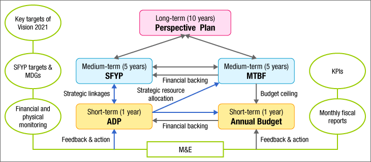
Source: Document of General Economics Division (GED), Planning Commission, Bangladesh government
FigureProportion of population below the lower poverty line (2010) & Pockets of social deprivation by Upazila
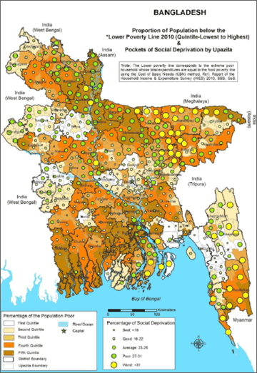
Source: Binayak Sen and Zulfiqar Ali, “Ending Extreme Poverty in Bangladesh During the Seventh Five Year Plan: Trends, Drivers and Policies”, Background Paper for the Preparation of the Seventh Five Year Plan, General Economics Division (GED) , Planning Commission, Government of Bangladesh, January 2015
- *Lower poverty line in this research corresponds to the households whose total income equals to the cost to take in nutrient requirements of food poverty line (1,805kcal/day).
- *Social deprivation index was created by multiple non-income index.
Recent trend of regional policy
<Direction of regional policy>
As it is mentioned above in the description of local administration system, local government in Bangladesh, although their existence is defined in the constitution, their actual authority and enforcement capacity are limited and their practical business is often run by outpost agencies of the ministries of central government.
Ministry of Local Government, Rural Development and Cooperatives is the ministry responsible for supporting local governments in various ways and it mainly deals with the following fields;
- —Support for local government. This is provided through Local Governance Support Project (LGSP) Recently, the ministry offers Basic Block Grant and Performance Block Grant which is offered according to evaluation of performance to the Unions.
- —Development and maintenance of local roads such as Upazila roads and Union roads and culverts.
- —Development and maintenance of water and sewerage. In large cities, Water and Sewerage Corporation directly governed by the ministry handles the development and management business.
- —Development and maintenance of village markets.
- —Affairs related to village police. Village police, apart from the police governed by the central government, is operating under the control of the ministry with a staff of around ten.
Local Government Engineering Department (LGED) of the Ministry of Local Government, Rural Development and Cooperatives deals with practical work such as development of local roads and it is respected for its highly efficient management. Budget of 39.2 billion taka for LGED itself (2009-10 FY) covers 14% of the total budget of Bangladesh government. Moreover, the department's number of staff counts up to more than ten thousand, 99% of which are working at the local level (District or Upazila). There is one office in every 64 Districts and in each office 12-13 staff members work under the director. Also, there are offices in 482 Upazilas across the country each of which comprises a director and about 18 staff members. The role of LGED is centered by implementation of infrastructure development in local level, such as works for roads, bridges, water/sewerage system, etc.
<Current state of disadvantaged regions>
Bangladesh, separated by large rivers such as Padma River, Jamuna River and Meghna River, was regarded until recently that poverty rate in the west was higher compared to that of the east. However, such disparity is narrowing (though there are still areas with comparatively high poverty rate partly in southwest, south-central and northwest areas). Due to the completion of Jamuna Bridge in 1998 and construction of Padma Bridge which is under way, further decreasing of disparity is expected.
On the other hand, in areas which can be regarded as comparatively rich area from the broad-based view, small poor areas remain which can be explained as “poverty pockets”. Dealing with such areas is the nation's current challenge.
In the planning process of 7th five year plan which is now being prepared, research on such regional imbalance was conducted.
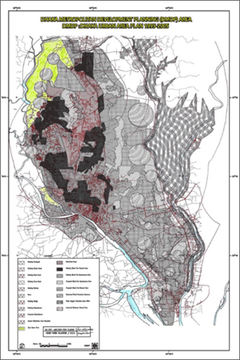
Plan for Metropolitan area (Dhaka)
<Plan of a major metropolitan region>
| Name | Dhaka Metropolitan Development Plan and relevant plans (Planning system of Bangladesh is basically three-tiered; Structure Plan, Urban Area Plan and Detailed Area Plan (DAP). These three plans and Dhaka Metropolitan Development Plan are the plans for Dhaka metropolitan area.) |
|---|---|
| Planning horizon |
|
| Establishing body | Capital Development Authority of Bangladesh (Rajdhani Unnayan Kartripakkha: RAJUK) (Establishment process will progress with the support of UNDP) |
| Legal Placement | Legal base of RAJUK itself are Dhaka Improvement Trust (Allotment of Land) Rule of 1969 and The Town Improvement Act of 1953. |
| Objectives and development strategies of the plan | <Objectives of Detailed Area Plan>
|
| Key features of the plan | Through the establishment of Detailed Area Plan, implementation of Structure Plan and others was stimulated by the following measures;
|
FigureDHAKA STRUCTURE PLAN (1995-2015)
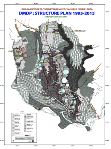
Source: Web page of RAJUK (Capital Development Authority of Bangladesh)
<Capital Development Authority>
Capital Development Authority (RAJUK) is managed by the committee composed of a chairman and five members, who are designated by the central government. Its superior organization is Ministry of Housing & Public Works (mohpw).
RAJUK is responsible for planning and development control of Dhaka metropolitan area.
- —Plans: The authority is in charge of establishment of various plans and actual construction of roads, bridges, etc.
- —Development Control: Implementation of development control based on the followings;
The Town Improvement Act 1953
The East Bengal Building Construction Act 1952 (Permission is required for all construction works.)
Covering area of RAJUK is Dhaka City and its surrounding Districts (1,528km²).
Development authority resembling RAJUK exists in every City Corporations in Bangladesh to implement spatial planning and development control (local governments do not participate in spatial planning and development management work in the current system and there is the opinion that ideally those work should be conducted by local governments).
Local Planning
<Local plans by the central government>
In Bangladesh, Ministry of Local Government, Rural Development and Cooperatives bear the responsibility of most of the local development such as development and maintenance of rural roads/bridges/underdrainage, development of markets and development of water/sewerage system.
Major local plans and others related to the ministry are;
- —Rural Development Strategy 1984
- —Rural Infrastructure Strategy Study 1996: Strategy to concentrate investment on specific areas which are designated as growth centers of rural areas (later in 6th Five Year Plan, 2,100 growth centers throughout the nation was designated).
- —National Rural Development Policy 2001
- —Rural Road and Bridge Maintenance Policy 2013
- —National Urban Sector Policy 2011: Materialization of regionally-balanced urbanization by decentralized and hierarchized urban system.
In Perspective Plan and in 6th Five Year Plan as well, which are the upper-level plans of the plans described above, measures such as promotion of infrastructure development in local areas (ex; development of rural roads) are included. It is especially emphasized that development of rural road would reduce production cost and bring expansion of job opportunities, and would improve access to medical service and education which may contribute to human resources development.
<Plans by local governments>
Recently, formulation of master plans for Pourashava(general cities)-level are progressing.
Also, formulation of master plans for Upazilas are progressing according to Article 23 of Upazila Parishad Act 1998 which clearly stipulates that Upazilas are obliged to establish a Five Year Plan and plans for different planning period.
However, ministries and agencies of central government including Ministry of Local Government, Rural Development and Cooperatives are engaged in formulation of master plans for Pourshava and Upazila.
It is pointed out that the plan is not linked with national-level plans such as Five Year Plan. (In large cities, master plans are established by Urban Development Authority placed in each city. The plan is a spatial plan but each development authority is governed by Ministry of Housing & Public Works and not by the local government. Again, it is pointed out that these master plans are not linked with Five Year Plan.)
Provision of social capital
As the territory of Bangladesh is divided by many large rivers such as Padma River, bridge construction is the national concern and currently a bridge construction is progressing on Padma River near the Capital city of Dhaka.
“Fast track projects” which are the infrastructure development projects prioritized by the government of Bangladesh include above mentioned Padma Bridge and also development of Dhaka Metro Rail, Rampal Coal Power Plant, Ruppur Nuclear Power Plant, deep water port and LNG terminal.
Among above projects, the government of Japan provides financial support of approx. 250 billion yen to Dhaka Metro Rail. Also the government provides approx. 300 billion yen to Matarbari coal- power plant in the southeast.
Trans-national spatial policy issues
<transport between neighboring countries>
Bangladesh shares borders with India and Myanmar and is comparatively close to Nepal and Bhutan beyond India.
Government of Bangladesh wishes to expand trade with India, Nepal and Bhutan and to make the ports be used by the eastern states of India, Nepal and Bhutan, but it has not become reality due to the obstacles such as road conditions, immigration control, customs, etc.
There is a scheme of connecting Bangladesh, China, India and Myanmar (from Kunming, China through to Calcutta, India) by high-standard highway (BCIM framework).
<usage of water resources of Padma River>
Flow rate of Padma River increases during rainy season and brings flood to Bangladesh, but in contrast, the flow rate significantly decreases in dry season.
Upstream of Padma River is at the territory of India and as India has constructed a dam just before the border with Bangladesh for the domestic usage of water, water volume in Bangladesh was caused to decrease to the extreme in dry season.
(Information Updated: March 2015)