
Country Profile
Table 1Cambodia fast facts
| Name of the country | Kingdom of Cambodia |
|---|---|
| Total land area | 181,035 km² (about 50% of that of Japan) |
| Population | 14,677,000 (2013) |
| Population density | 81/km² (2013) |
| Urban population ration | 30.0% (2015) |
| GDP | USD 177 mllion (2015 est.: IMF) |
| GDP per capita | USD 1,140 (2015 est.: IMF) |
| Ratio of people employed by industry | agriculture: 48.7% industry: 19.9% services: 31.5% (2013 est.) |
| GDP growth rate | 0.1% (2009), 6.1% (2010), 7.0% (2011) 7.0% (2012), 7.0% (2013), 7.0% (2014) |
(Information Updated: March 2017)
Cambodia is located in the Indochina, and has border with three countries: Thai in the northwest, Laos in the north and Vietnam in the southeast. The total land area of Cambodia is the third smallest in the ASEAN countries after Singapore and Brunei. In Cambodia, there run two large rivers Tonlé Sap and Mekong. The Tonlé Sap River has its headstream in Tonlé Sap Lake, the largest freshwater lake in the Indochina and Mekong river whose headwaters are in Tibet plateau. Most part of the country is a flat land.
Cambodia is a multiethnic state. Approximately 90% of its nation are Khmer whereas the remaining 10% is composed of 36 different ethnic minorities such as Cham, Vietnamese, and Chinese. The minorities other than Cham and Vietnamese live in the hilly terrain near the east and the northeast boarder.
Population and economic activities are heavily concentrated on less than half the country's land. For 2013, this would mean 90% of nearly 15 million people live on only 80,000 sq km, resulting in relatively high densities, compared with the very low densities at the periphery.
The urban concentration in the most fertile river valleys and flood plains is a highly predictable consequence of the changes from an agrarian to an urban-industrial pattern of development, while more dykes and other technical flood management measures are indispensable to cope with natural setting of temporarily flooded lowlands which is inappropriate for urban development.
The largest city is the capital city Phnom Penh (population: 1,573,000 as of 2015) followed by Sihanoukville (156,000), Battambang (150,000) and Siem Reap (139,000). The capital city Phnom Penh is located along the so called “Southern Economic Corridor,” between Ho Chi Minh and Bangkok.
Cambodia has 24 provinces and 26 municipalities (including Phnom Penh Capital). The red dots below in Figure 1 show location of provincial capital based on urban reclassification (2011, using 2008 population census of ministry of Planning)*.
Figure 1Regions, provinces, municipalities, and some major topographic features
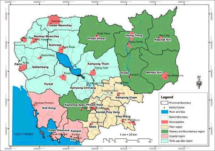
Source: Cambodia Urbanization Study, ADB, 2014
- * The size of the urban administrative area of each municipality was demarcated based on existing district boundary (before Organic Law, 2008 come into force), which does not reflect neither scale of population, density and economic structure.
Figure 2Administrative Structure
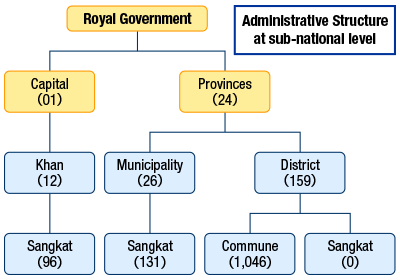
- Notes:
- Royal Govt. is elected every 5 years through popular election; Governor of Capital, province and Khan/District/Municipality are appointed by the Government-led ruling party, Councils of Capital, Province, Khan/District/Municipality are indirectly elected by Commune/Sangkat (C/S) Councillors, and chief of C/Sand council is popularly elected every 5 years.
Source: Reproduced based on Organic Law, 2008
Local Government System
Cambodia is composed of its capital city Phnom Penh and 24 other provinces. Its basic framework for the establishment of administrative region was initiated and established during the era of French rule. Initially, there were not even councils established in the provinces and the local governments were appointed as local agencies of the central government (the Ministry of Interior). Therefore, the local administration body of the national government had a strong influence over local governance. However, in 2001, with an aim of bridging local authority closer to poor and marginalized people and having increased roles and responsibilities to address local development challenges in their jurisdictions, election law and organic law for administrative management of Commune/Sangkat were adopted, allowed the Commune/Sangkat councils directly elected for the first time in February 2002. In 2005, National Strategic Framework for De-concentration and Decentralisation was adopted by the Council of Ministers, paving the ways for the Government to completely achieve the reform for unified administration at sub-national levels. Further, in 2008, organic law on administrative management of Capital, Province, and District/Khan/Municipality was adopted as a result of amendment of constitution. In this effort, Councils at Capital, Provincial, and District/Municipal/Khan levels were indirectly elected for the first time to oversee the accountability performance of Board of Governors for the delivery of services to citizens. Although the Sub-National Administrations are established, built, and promoted in Cambodia, however, these structures remain under a strong influence of the central government, it is gradually forming the two layered structures for administrative and planning system.
The relations between government agencies at the central and provincial levels are characterized by a mix of centralized, deconcentrated and decentralized features. Both the province/municipality and district/khan are coordinated by the appointed representatives of the government called the governors. The relations between ministries and all institutions (departments) at national, provincial/municipal, and district/khan are unclear due to huge delay for the transfer of power and functions between key national ministries to sub-national level, particularly Districts and Municipalities. However, the foundation of 23 new municipalities in 2008/2009 (in addition to the pre-existing four old municipalities) added more clarity to the structure, creating a semi-autonomous level of municipal administration. The centralized system remains the backbone of the day-to-day management and administration. The election of commune/sangkhat councils since 2002 changed the system from a completely centralized to more decentralized style, and that was reinforced by the district/municipality indirect elections since 2009. So key roles and duties are being gradually and systematically delegated to lower levels of government that are simultaneously being created.
At the intermediate level of province and municipality, the management system is still fragmented in terms of planning, budgeting, and staff. Due to the overlapping roles and responsibilities and the absence of a “Unified Administration Code”, the management of provinces and municipalities still faces major obstacles. However, after the creation of new municipalities in 2009, the administrative complexity has improved. The lower level of district (called khan within urban areas) is directly responsible to the higher level of province or municipality, but the great differences in area and population size of districts make service delivery and planning difficult.
Planning System (Socio-economic and Physical Planning)
The two planning systems are adopted for the country, which is the “Socioeconomic Development Planning” which is owned by the Ministry of Planning (MoP), and “Spatial Planning” which Ministry of Land Management, Urban Planning and Construction (MLMUPC) is in charge of. The Rectangular Strategies of the national government is a top policy platform of the Ruling Party, the backbone agenda of socio-economic policy, the 5-years National Strategic Development Plan, sectorial strategies and plans including physical spatial planning. The Ministry of Planning appears to be following, rather than leading efforts towards a stronger, consistent national planning framework that includes National Strategic Development Plan (NSDP); and as such the Ministry plays a rather passive role. Ministry of Planning in Cambodia is primarily dealing with socio-economic planning across the Government's ministries/institutions. So its role is quite different from the MLMUPC with its emphasis on land management and physical planning.
While socio-economic development planning is structured at two levels, i.e., the national and sub-national level, and firmly rooted, the physical planning is still premature, and limited to capital, provinces and some cities. At sub-national level, Capital, Provincial, District/Municipal (DM) Development Plans (5 years) and Rolling Investment Plans (3years) are developed by the board of governor and adopted by its council for capital/provinces, and Districts/Municipalities. At commune/sangkat level, rolling investment plan (3 years) is prepared (based on a 5-year commune development plan) and integrated to district investment plan (through District Integration Workshop/DIW), and also link to the provincial investment plan due to some local development priorities and challenges beyond the capacity of the district and commune authorities. Currently, DM is a more focus in the local government reform agenda, therefore, the NCDD is scrutinizing planning system, resources allocation, power and functions (2016) to ensure stronger accountability mechanisms for the delivery of public services. DM fund and Commune/Sangkat (CS) fund including SNIF (Sub-National Investment Fund) are core elements to ensure integrated planning and clear division of responsibilities between both levels. In addition, the NCDD is implementing a plan (2015-2017) on social accountability framework (I-SAF), aiming to increase the accountability capacity of DM and CS councils and its administrations as well as to implement demand-side development approach by increasing satisfaction of citizens through citizen engagement, monitoring and empowerment. It means that participatory approach for local planning and budgeting including open local budget is crucial for the implementation of SAF 2015-2017. Therefore, planning and budgeting will certainly strengthen the accountability of board of governor to the council, and accountability of councils to citizens as well as accountability of all sub-national administrations to comply with national laws and standards (e.g. I-SAF).
The Ministry of Planning is mandatory to coordinates the formulation of NSDP (the second top plan after RS) and oversees the progress of NSDP, and plans for the next mandate of the national government by incorporating needs and challenges of different sectors ministries. Various donors and national government agencies provided inputs to the NDSP by sector and by their expertise and areas of support. Physical/spatial planning appears to be lag behind, although basic laws/regulations were prepared for example land policy and land law 2001, owing to the limit of financial and capacity to plan particularly at sub-national level. Some urban development regulation, for instance sub-decree 86 on construction permits (1996) is out of date against an amended land law (2001). Political commitment both at national and sub-national level should have been playing important role to encourage technocrats to plan and to be endorsed by the government. But it has not been much of the case.
Table 2Planning Hierarchical Systems
| Types of Plan | Spatial Plan | Socioeconomic Development Plan |
|---|---|---|
| National level | National Policy On Spatial Planning | Rectangular Strategy (now phase-III, 2014-18) |
| National Spatial Planning | National Strategic Development Plan | |
| Broader regional level | Regional Spatial Planning | |
| Circular on Cambodia Coastal Area Management (February, 2012) | ||
| Capital/Provincial Level | Capital Land Use Planning and Master Plan (Phnom Penh Strategic Orientation 2035 has been approved in principle in December 2015-15 years vision) | 5 years development plan, 3 years rolling plan, and 1 year development plan (project execution base on national budget) |
| Provincial Spatial Plan | ||
| Municipal/District/Khan | Municipal Land Use Plan (Battambang LUP has been approved in December 2015-15 years vision) | 5 years development plan, 3 years rolling plan, and 1 year development plan (project execution base on national budget) |
| District/Khan Land Use Master Plan | ||
| Commune/Sangkat level | Commune/Sangkat Land Use Planning | 5 years development plan, 3 years rolling plan, and 1 year development plan (project execution base on national budget)-Commune/Sangkat plan is subject to be integrated into the District integration Workshop (DIW). |
Authorities Relating to Spatial Policy
| Program name or administrative field | Organizations | Webpage |
|---|---|---|
| Socioeconomic Development Planning | Ministry of Planning (MoP) | http://www.mop.gov.kh/ |
| Spatial Planning | Ministry of Land Management, Urban Planning and Construction (MLMUPC) | http://www.mlmupc.gov.kh/?page=&lg=en |
Planning Authority (Spatial Planning)
At national level, the Ministry of Land Management, Urban Planning and Construction (MLMUPC) leads the spatial planning tasks as per role and function defined in the establishment of MLMUPC in 1999. The core ministries involved in spatial planning matters are, besides the MLMUPC, the Ministry of Interior, and the Ministry of Public Works and Transport, the Ministry of Economy and Finance, and the Ministry of Environment and others which formed the National Committee for Land Management, and Urban Planning (the committee is chaired by minister of MLMUPC). 22 national ministries are represented in the NCLMUP where all major decisions are vetted before they are taken by the cabinet. The key role is to advice on territorial planning including technical aspects, and decision prior the final endorsement to be made by the Council of Minister. At sub-national level, the sub-committee of LMUP (chaired by provincial governor) plays similar role with the technical supports from various line departments of the national ministries.
All local plan will have to be aligned with national government's policies which the overarching decentralization and deconcentration (D&D) policies* are very important, with a strong impact on any spatial and economic policies affecting all cities and towns. Right after the emergency relief phase of re-building Cambodia in the early 1990s, the D&D experiment phase were introduced with long-term support by UNDP and all other foreign aid agencies and D&D reform become official in 2002 after first election of CS councils. These overarching policies are still being expanded and filled in by means of the entire planning system on land management and local administration. The land management sector has been supported by international aid for nearly 20 years and will be likely further supported, along with international support to the urban planning and management functions at national and subnational levels.
- *National Programme on Sub-National Democratic Development (NP-SNDD) 2010-2019 and its 3 years Implementation Plan (IP3) 2015-2017 is designed to support the implementation of Organic Laws and in full swing of implementation.
Features of Socioeconomic Planning
In 2004, a document titled “Rectangular Strategy for Growth, Employment, Equity, and Efficiency” (hereinafter, the Rectangular Strategy) was issued, to present a comprehensive national development strategy of the new administration built in the previous year. The strategy extracted key elements from the “Cambodia Millennium Development Goals”, the “Socio- Economic Development Plan 2001-2005”, and the “National Poverty Reduction Strategy 2003-2005”, and inherited the traditional “Triangular Strategy” of the government. Followed by the issuance of the “Rectangular Strategy-Phase II” in 2008, the current “Rectangular Strategy –Phase III” (RS III) was issued in 2013.
The government of Cambodia holds a vision of being ranked as mid/high-income country by 2030 and high-income country by 2050. The RS III plays a vital role as a base for realizing this vision, as it promotes national development and poverty reduction with a long-term sustainability through: Promotion of Agricultural Sector; The Development of Physical Infrastructure; Private Sector Development and Employment; and Capacity Building and Human Resource Development.
The “National Strategic Development Plan (NSDP)” plays a role of 5 years action plan for making the policy guidance, the “Rectangular Strategy”, feasible. As for NSDP, its initial version was the NSDP 2006-2010 which was approved by the cabinet* in 2006 as a 5-year plan combining the “Socio- Economic Development Plan –Phase II (2001-2005)” and the “National Poverty Reduction Strategy (2003-2005)” (Cambodian version of “Poverty Reduction Paper“, a collaborated request from the World Bank and the IMF to 72 developing countries). NSDP 2006-2010 was updated for the period of 2009-2012 rather than new formulation, allowing the next NSDP formulation to align with the cycle of RS-III 2014-2018 of the government of the fifth legislature of national assembly.
The RS III serves as a policy framework, a roadmap of NSDP**. The “Key Policy Priorities and Actions 2014-2018” of NSDP2014-2018 is consisted of 6 pillars: “Good Governance: The Core of the Rectangular Strategy”, “Overarching Environment for Implementing the Strategy”, “Promotion of Agricultural Sector”, “The Development of Physical Infrastructure”, “Private Sector Development and Employment”, and “Capacity Building and Human Resource Development”. Efforts and measures for spatial development are mentioned in each of the pillar individually. There are however questions on measurement indicators of the progress of NSDP and authority to do so. Ministry of Planning does not seem to have sufficient resources to assess the results, but national each ministry who often wanted to prioritize its territorial entity. To support the achievement of NSDP 2014-2018, the Government has assigned the Council for the Development of Cambodian to develop Development Cooperation and Partnerships Strategy (2014-18) aiming to improve the capacity of sector ministries (TWGs), oversee development assistance and partnership arrangements with traditional and new emerging donors to achieve development effectiveness rather than aid effectiveness.
- *Council of Ministers is an avenue for adoption of national policies and legislations before submission to parliament
- **Ministry of Planning (MoP), in charge of planning the NSDP, states that “The NSDP is the single, overarching, guiding and reference document of the RGC and the ‘blue print for further progress’ in building a new Cambodia. Government and external development partners are expected to align their supports with the priorities set out in the NSDP.” (http://www.mop.gov.kh/Home/tabid/36/Default.aspx)
Features of Physical (Spatial) Planning
The Royal Government's Rectangular Strategy for Growth, Employment, Equity and Efficiency, Phase III (RS-III) and the current National Strategic Development Plan 2014-2018 consolidates and outlines the Royal Government's goals, objectives, and actions to be achieved during the fifth mandate of the Royal Government and beyond. The RS-III identifies, “four priority areas” including ‘responding to urban development’ (section 14, para. 2). Which will contribute to “outcomes including: (i) lower transport costs; (ii) Improved reliability and effectiveness; (iii) Improvements in competitiveness; and (iv) increasing in investment in (economic and industrial development and) trade”. RS-III also highlights the need for “managing (the) environment and climate change (which) has become another challenge for the sustainability of Cambodia's economic growth and social development, due to pressures from population growth and urbanization”.
To achieve these prioritised objectives, the Royal Government will focus on (i) promoting the comprehensive land policy through the “White Paper on Land”, and (ii) the preparation of a Law on Land Management and Urban Planning”, to which the National Urban Development Strategy process will contribute. The NUDS will also assist in giving more attention to urban infrastructure and economic development needs through industrialisation and modernization as key factors in supporting economic growth and development, enhancing economic efficiency as well as strengthening competitiveness and promoting Cambodia's economic diversification, especially for poverty reduction. The Government has also prioritised its intentions to;
“Enhance (the) welfare of people and ensure environmental sustainability through consistency with the framework of land management and urban planning (see RS-III section. 73), including the National Policy on Housing, and developing new laws related to land management, urbanization and construction, and a National Strategy on Development of Municipal and Urban Areas*” (see RS-III section. 77, paragraph 6). “Preparing a Master Plan for Urban Infrastructure Development”, and ensure consistency with the evolving legislative framework on land management and urban planning, and prepare a National Strategy on Development of Municipal and Urban Areas, (paraphrased from NSDP, section. 4.103, paragraph. 6).
“Develop a policy to manage the movement of people within the country in consonance with the implementation of strengthened land management and urban planning policies. Focusing on: (1) Development of Phnom Penh, and other key economic poles, satellite cities and urban areas of the country, while making efforts to create jobs in these communities; and (2) Linking satellite cities and urban areas with important economic poles and centres to form economic corridors” (see RS.III section. 133).
The NSDP 2014-2018 also recognises the challenges for sustainability of Cambodia's economic growth and social development due to population growth, urbanization, climate change and disasters, and other factors, (see NSDP section 4.39). It states that during the five-year life of the NSDP, RGC “intends to intensify land reforms, focusing on strengthening the management, organisation, utilisation, and distribution of lands. That will contribute to reducing poverty, protecting the environment, and (promoting) socio-economic development, within a market framework” including “the preparation of Law on Land Management and Urban Planning” and other inputs (being drafted as of January 2016). The Ministry of Land Management Urbanisation and Construction (MLMUPC) is committed to undertaking a wide range of actions (see NSDP section 4.62) within its mandate including**:
- Approving a Law on Land Management and Urban Planning, and related legal policy documents to implement this Law.
- Adopting and effectively using, the hierarchy set by the Policy on Land Management, and the Royal Decree and Sub-decree on the Establishment of Committees for Land Management and Urban Planning at all levels for land management plans in municipalities and provinces.
- Continue to adopt the National Housing Policy, in order to resolve housing problems for poor people so they can live in safety, welfare, and in dignity.
- Continue to provide technical support to the councils of all municipalities, districts, khans, communes, and sangkat in the preparation of master plans and land use plans.
- Strengthen the effectiveness of work on collection, compilation, and production, as well as the dissemination of data and statistics for land management and urban planning
Mutually these will guide and influence national and urban development in Cambodia for the coming period and will be crucial in giving and expressing overall direction and guidance for developing the National Urban Development Strategy (NUDS). They will also influence future national policies, strategies and plans, which will require urban strategies to be adaptive and flexible to meet and address evolving and changing priorities.
In the latter half of the 2000s, trial of Participatory Land Use Planning and Commune Land Use Planning at the rural community level kicked off in Cambodia. The effort of introducing spatial planning began in relation to delegation of land management authority to the local level. Further, it became to be perceived that spatial planning is indispensable for the sustainable development of Cambodia. However, system for the spatial planning is still under development. In the “National Spatial Planning Policy” approved by the council of ministers in April 2011 shows the hierarchy of spatial planning they are aiming***.
“National Spatial Planning Policy” states that spatial planning of each level of administration, Land Use Master Plan and Land Use Planning will be set force based on the principle of decentralization of power and various laws concerning the management of local administration. It classifies the planning of each level of administration broadly into the following:
- Regional/ global Supra national level: Economic Cooperation Development Plans (for example, within ASEAN and Greater Mekong Subregion)
- Planning in the national level (National Spatial Planning and Regional Spatial Planning targeting areas broader than a province); and
- Planning in the sub-national level (3 levels of planning such as Capital/Municipal: Capital, Municipal Land-Use Master Plans and (more detailed) Land-Use Plans, District/Khan level: District, Khan Land-Use Plans, and Commune/Sangkat level: Commune, Sangkat Land-Use Plan (CLUP), and local project development plan (example, community upgrading, land sharing, concrete road rehabilitation projects, etc.)
Although the legal basis is now (2015) much more complete than only a few years ago, the system remains to be one of policy declarations and regulations, without adequate implementation in practice. The system of plan making thus mainly consists of draft regulations as in the National Policy on Spatial Planning (2013). Here, an impressive hierarchy of cross-sector physical plans are proposed, from the communes up to the national programs. Cambodia has also begun to participate in interactive planning and policy making with the neighbouring countries, for example, in the Greater Mekong Subregion (where the Asian Development Bank assists the six participating countries in their work). The Figure below illustrates the intended hierarchy of land use plans and master plans.
Figure 3The hierarchy of area plans, from the lowest level (Commune) to the national level and above
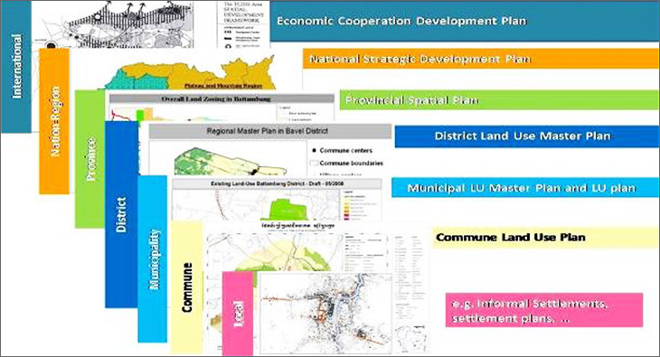
Source: National Policy on Spatial Planning (2013)
Characteristics of the plans for each level are as per described below (as spelled out in the Organic Law, 2008).
Table 3Description of Spatial Planning System from National to Local Level
| National/Regional Level planning |
Shall be developed by the National Committee on Land Management and Urban Planning, established by Royal Decree under the leadership of MLMUPC, and be adopted by Royal Decree. The plan shall have its vision for at least 20 years and shall be revised after 10 years through the request of Royal Government except there is a necessity then the revision could be made before this period. |
|---|---|
| Capital/Provincial Level planning |
Shall be developed by the Capital/Provincial Committee on Land Management and Urban Planning, which is set up by sub-decree, with coordination from Capital/Provincial Council with approval from National Committee on Spatial and Urban Planning and adopted by sub-decree. The plan shall have their visions and last for at least 20 years and could be revised in every 5 years. |
| Municipality/District/ Khan Level planning |
Shall be developed by the Municipal/ District/Khan Committee on Land Management and Urban Planning, which is set up by sub-decree, with approval from Capital/Provincial Council and adopted by the Chairman of the National Committee on Spatial/City Planning. The plan shall have their visions and last for at least 15 years and could be revised in every 5 years. |
| Commune/Sangkat Level planning |
Shall be developed by Commune/Sangkat Council with coordination and technical support from Municipality/District /Khan Council on Land Management and Urban Planning. It shall be approved by Capital/Provincial Council through Capital/Provincial Committee on Spatial and Urban Planning. The plan shall have its vision and last for 10 -15 years, and can be modified in every 5 years, based on the need, situation of local development and especially commune/Sangkat investment program. |
The planning system is seemingly highly developed by now but in reality, not many plans for municipalities have been elaborated (all by national government, with some participation at the local level), but they have not been nor approved yet (by the national cabinet). With exception, The City of Battambang and its Land Use Plan has been approved early in December 2015 because of great advantage of more than ten years foreign technical aid, primarily from the German GIZ. Similarly, the Strategic orientation for Phnom Penh Capital with time horizon of 2005-2020 had been developed and discussed since 2002, and was only approved in principle in December 2015 (revised to as 2035 horizon).
- *The National Urban Development Strategy (NUDS) corresponds to this National Strategy on Development of Municipal and Urban Areas
- **Quoting from NSDP, Planned Actions to Implement the Prioritized Policies (section 4.63), Land Management and Urban Planning subsection
- ***This document, put together by the General Secretariat of the Council for Land Policy with the cooperation of German Agency for International Cooperation (GIZ), presents to the government the vision, goals, objectives and strategies to ensure the sustainability, equity, equilibrium, and the integration of developments within the country, region, and international arena.
Metropolitan and Other Regional Planning Systems
The urban planning system and its instruments
Several laws/regulation are being drafted to with respect to territorial management. This will require consideration and harmonisation with the National Policy on Spatial Planning and the Organic Law. The National Urban Development Strategy Framework (NUDSF) has been drafted (December 2015) providing guidance to a fully-fledged NUDS to be prepared in the future. The NUDSF stated that NUDS should contribute to and give guidance to existing and evolving system for master, land use, detailed plans and other specific plans (as designated) as they are drafted and implemented at various levels of government. In the future, relevant sector based plans should incorporate and refer to the NUDS as a prevailing tool for coordinating national and local goals and objectives in urban areas.
Jointly spatial and environmental frameworks and the administrative structure (the capital, provinces, municipalities, khan/district, and other sub-national administration areas such as communes/Sangkat) form the basis for the planning hierarchy, which may require further developments in planning legislation to enable and synthesis sector/area based plans, which may be developed. Clearly defined roles for local authorities exist; the Law on Administrative Management of the Capital, Provinces, Municipalities, Districts and Khans (the Organic Law#2-2008), Law on Commune/Sangkat Administrative Management (Organic Law#1:2001), the National Policy on Spatial Planning and the Sub-Decree on the Establishment of Committees for Land Management and Urban Planning (at different levels). There is also a need for capacity development and guidance for them as well as for clarifying the roles, responsibilities, and inputs to be provided by other national agencies and their subordinate entities. All development plans will have some resource requirements (natural, financial and human), and these need to be considered at an early stage to ensure that cost effective and implementable plans are developed and adopted.
The NUDSF also emphasized on the needs for considering the Supra National, Regional Development Planning and Cooperation Requirements and Factors. (Including planning coordination between neighbouring regions/cities and distribution of employment and population). There is a need for a broad conceptual division of the national territory into a number of possible development areas (agricultural, tourism, industrial,-or where Special Economic Zones-SEZs exist, and urban settlements) and protected areas (national parks, nature reserves, other biodiversity conservation areas, as well as for heritage and cultural conservation). The coastal areas will require special attention to balance the competing interests from possible resource exploitation (oil and gas reserves), industrial, tourism and urban settlements (port cities and industrial complexes), as well as recreation and nature conservation areas and the increasing risks from climate change. Including consideration of new urban centres, that may be proposed and created as well as for population and employment distribution.
Regionalization for analysis and policy purposes
The present system of five or six statistical regions may need to be reformulated to a system of more appropriate planning regions. This will require consultation and consensus with other government institutions/ministries and stakeholders to ensure coordination and alignment between them. A possible proposal for adjusting the planning regions, would consider – Metropolitan Phnom Penh, border regions, other planning regions, based on geographic, economic, and administrative criteria. There will be a need to encourage and support sub-national regional planning with cooperation between cities, urban and rural areas along economic corridors for their mutual benefit.
The macro-regional development framework of the Greater Mekong Sub-region (GMS) and ASEAN also needs to be considered especially for border provinces and urban areas. Where urban development across national boundaries is now to be handled by a special Urban Taskforce under the GMS ministerial conference. Further reference may be needed to integrate current and emerging policies from ASEAN and its ending ASEAN Economic Community (AEC).
During the recent decades, Cambodia has stepped ahead in establishing a fair amount of policies, strategies, laws and regulation pertaining to land management, and urban planning. Some important policies are summarized below:
The National Policy on Housing is likely to be one of the important components of the NUDS, as it is intended to regulate and facilitates processes for the provision of and or encouragement of cost effective and affordable housing for poor and vulnerable families. As well as addressing informal settlement issues.
Comprehensive Land Policy (“Land White Paper”)
Improving land tenure through property titling may need further refinement, as significant increases in values due to urban expansion are not being captured by the state. Potential “capital gains” through the increased opportunities for local taxation to contribute to revenues available to sub-national administration need to be considered, in which land conversions and changes of use significantly increase the values, some of which may need to be captured by local authorities for the operation budgets. Other aspects of the policy will need to be mainstreamed and incorporated into the NUDS.
The Royal Government has adopted a cross cutting National Green Growth Policy and Strategy in 2013 and it has been mainstreamed into the National Strategic Development Plan 2014-2018 as an essential means to sustainable development and aspects of this policy need to be adapted and incorporated to NUDS as does the consideration of the “3E approach” (economy, environment and equity).
The recently adopted Industrial Development Policy highlights the need to better consider the rapidly changing and diversifying economy that is transitioning Cambodia. It identifies possible thrusts for industrial development that will be linked to expanding the connectivity of growth centres and corridors and the future possible roles for urban expansion. As well as the proposed development of an industrial zoning and development master plan, aimed at “promoting competitive SMEs and industries in designated provinces”.
The Government intends to provide essential support, including, “promoting spatial planning and urban development in designated industrial regions such as in Svay Rieng, Sihanoukville and Koh Kong provinces and Paoy Paet Municipality to coordinate industrial activities aimed at enhancing land use planning, environmental management, residential development and infrastructure development. Developing Phnom Penh capital into an industrial agglomeration through implementing a long-term urban development plan with clear designation of industrial, administrative and residential areas, aimed at transforming Phnom Penh into a dynamic centre of culture, knowledge and industry.
Integration of Transport and Land Use Planning
The majority of current transport routes connect and transit the main urban centres in the country and as these grow, transiting and locally generated traffic and the movement of goods and produce will take longer to get to their destinations. This will need to be monitored and alternative routes planned and developed. Additionally some urban centres are dispersed requiring motorised traffic to get around which is excessively wasteful of energy and resources, in this context how to reduce motorised dependencies through planning and development will be crucial. Compact cities and town concepts as well as ‘public transport policy and approaches for smaller towns need to be explored.
In “The Development of Physical Infrastructure”, policies for development of the national transportation network are stated. It states that master plan for improvement of transportation infrastructure across the national territory as well as those connecting with neighboring countries are to be developed and implemented with an aim of facilitating investment, trade, tourism and rural development. It also states that the focus should be placed on the restoration and maintenance of railway system (restoration of north line between Phnom Penh and Poipet to connect to Thailand), further maintenance of infrastructure of airport and seaport, appraisal of investment possibility in the inland waterway transport and so on. In addition, it states that construction of high speed roads is to be encouraged, giving first priority to route between Phnom Penh and Sihanoukville. Moreover, it is projected that national, provincial and rural roads will be paved at the speed of 300 to 400 km per year.
Figure 4GMS Economic Corridor and Priority Border Areas
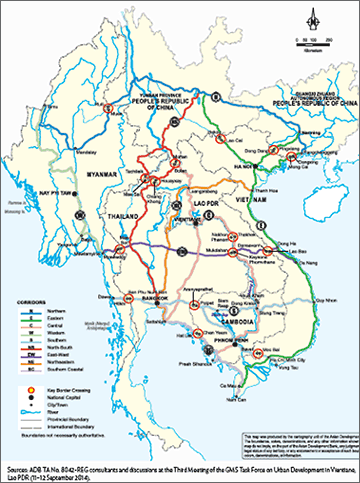
Source: ADB-TA No. 8042 REG, September 2014: GMS Economic Corridor and Priority Border Areas
Expressway development plans
Reportedly JICA is supporting a major expressway project that will reduce travel time from Phnom Penh to Ho Chi Minh City from 6 to 3 hours only. The expressway which will also include a connection to Sihanoukville will be operational by 2020. The expressway project and the many improvements to national roads will enhance connectivity among the urban centres primarily within the core area, but much less so with the under-urbanized periphery [Preliminary Feasibility Study for Phnom Penh-Ho Chi Minh City Expressway Development Plan, Study is underway commissioned by JICA, 2014].
National integration has been one of the purposes for making heavy investment in infrastructure. In order to reduce poverty in the rural areas throughout the nation, the government has been investing in construction/improvement of roadways that connect major cities with rural areas, with an aim of reinforcing connection between villages and the cities, so as to provide markets for agricultural products for village residents and to create opportunities for improving their lives.
The GMS framework 2014-2022 intends to connect countries in the Sub-Mekong region including Cambodia, Yunnan province and Guangxi Zhuang autonomous region in the People's Republic of China (PRC), Lao PDR, Myanmar, Thailand, and Vietnam with Collective Vision: “Sustainable urban development in the Greater Mekong Sub-region” encompasses important aspects such as: Economic corridors are an efficient way to maximize their effectiveness; Special economic zones (SEZs) are essentially an economic tool rather than an urban or regional planning measure; and Economic corridors and SEZs have a role to play in regional, national and urban development in the GMS countries. See Figure 4 below.

- Information update:
March 11, 2016 - Contributor:
Dr. Makathy Tep
Director/Founder, Cambodian Institute for Urban Studies (CIUS)