
Country Profile
Viet Nam encompasses an area roughly the size of Japan except Kyushu Island. About three quarters of the country is covered by mountains and plateaus. Flatlands are mostly limited to the coastal Red River and Mekong deltas.
Since the Doi Moi reforms of 1986, Viet Nam has embarked on a path towards a market economy and openness. In terms of land use, this policy has meant that the country has seen unprecedented levels of industrialization in rural outskirts driven by foreign investment and rampant expansion of residential land into what were once rural areas on urban outskirts.
Viet Nam is administratively divided into three regions (northern, central, and southern) and six socio-economic sub-regions.
The poverty rates are relatively high in the highlands, remote areas, isolated areas, and areas where ethnic minorities live. Geographically, 64% of the impoverished population lives in the northern mountainous, northern central, central highlands, and central coastal sub-regions of the country.
TableViet Num fast facts
| Country name | Socialist Republic of Viet Nam |
|---|---|
| Surface area | 329,241 km² |
| Population | About 92.70 million (2014: UNFPA eat.) |
| Population density | 282/km² |
| Percentage of urban population | 33.6% (2015) |
| GDP | USD 201.9 million (2016) |
| GDP per capita | USD 2,215 (2016) |
| Percentage of employment by industry | agriculture: 48% industry: 21% services: 31% (2012) |
| Economic growth rate | 6.21% (2016: GSO) |
(Information Updated: March 2017)
FigureMap of Viet Nam
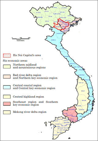
Source: Viet Nam Institute of Architecture, Urban and Rural Planning (VIAP) website
Local Governments and Spatial Planning System
| 1st | 2nd | 3rd | |
|---|---|---|---|
| VIET NAM | Centrally-Controlled Cities (5 cities: Ha Noi Capital, Ho Chi Minh City, Hai Phong, Da Nang, Can Tho) |
Districts | Wards |
| Prefectures | Townships | ||
| Counties | |||
| Towns | Wards | ||
| Counties | |||
| Provinces (58 provinces) |
Prefectures | Townships | |
| Counties | |||
| Prefecture-level cities | Wards | ||
| Counties | |||
| Towns | Wards | ||
| Counties |
Viet Nam has a three-tiered system of local government.
According to Article 110 of the 2013 Constitution (Enacted on 1st Jan 2014) Viet Nam consists of provinces and centrally-controlled cities. A province consists of prefectures, prefecture-level cities and towns, while a centrally-controlled city consists of districts, prefectures and towns. A prefecture consists of townships and counties; a prefecture-level city or a town consists of wards and counties; and a district consists of wards.
Special economic-administrative units/areas are established by National Assembly.
According to Article 4, Provision 2, Chapter I of the Law on Urban Planning, urban centers are classified into 6 Grades, including Special Grade and Grades I, II, III, IV and V:
- - Centrally-controlled cities must be an urban center of Special Grade or Grade I.
- - Prefecture-level cities must be an urban center of Grade I, II or III.
- - Towns must be an urban center of Grade III or IV.
- - Townships must be an urban center of Grade IV or V.
According to Urban Development Agency, on 31st Dec 2014, there were total 774 cities and towns including: 2 cities at Special grade, 15 cities at grade I, 21 cities at grade II, 42 cities and towns at grade III and 68 towns and townships at grade IV and 626 townships at grade IV. However, 50 % of urban population is concentrated at 16 big cities.
There are two main programs related to national spatial policy: the Viet Nam Socio-economic Development Plan, and the Spatial Plan.
Figure:Administrative system
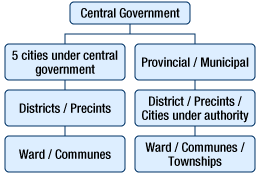
Figure:Planning system
3 types of plan are practiced horizontally
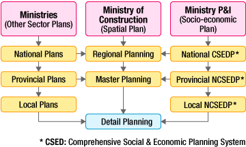
Sources: "Report on the 2008 National Spatial Policy Seminar" (2009)
National and Regional Planning Bureau, MLIT, Japan
Major Authorities Relating to Spatial Policy
| Program name or administrative field |
Organizations | Webpage |
|---|---|---|
| 10-year socio-economic development strategy and 5-year social-economic development plan | Ministry of Planning and Investment | http://fia.mpi.gov.vn/Home/en |
| Master Plan Orientation for Viet Nam's Urban System Development to 2025 with Vision to 2050 | Ministry of Construction | http://www.xaydung.gov.vn/web/guest/english |
| sub-region plans (multi-provincial regional plans) and metropolitan region master plans | Ministry of Construction | http://www.xaydung.gov.vn/web/guest/english |
Socio-economic Planning Systems at the National Level (Viet Nam Socio-economic Development Plan)
The two components of the centrally-planned Viet Nam Socio-economic Development Plan are the 10-year "Socio-economic Development Strategy" and the corresponding consecutive two "Five-year Socio-economic Development Plans". The stated objective of the current 10-year strategy is "to accelerate national industrialization and modernization along the socialist line and to build the foundation for the country to basically become an industrialized nation by 2020."
The 10-year strategy program was initiated after the 1986 Doi Moi platforms of reforms were introduced. The 2011-2020 10-year strategy in Viet Nam is the third of its kind. The five-year plans, on the other hand, well predate the Doi Moi reforms. The 2011-2015 five-year plan is Viet Nam's ninth.
Both the 10-year strategies and five-year plans fall under the jurisdiction of the Ministry of Planning and Investment (MPI). The MPI is the primary government organ delegated with the responsibility of coordinating with the relevant agencies involved in the drafting of the plans and with producing the final documents. The proposal developed by the MPI is finalized after official deliberations by the government and within the Communist Party.
Under the Viet Nam Socio-economic Development Plan scheme, a bottom-up mechanism is employed whereby local governments (counties, districts, and provinces) issue proposals to the higher levels of government, which are then ultimately and eventually send to the MPI, where they are incorporated into the country's overall spatial/land development policies.
Spatial Planning System at the National and Regional Levels
In 2013, the Law on Construction was enacted which included Chapter II on Construction Planning.
According to Article 13, Law on Construction 2013, Construction Planning consists of 4 kinds of planning as the following:
- 1Regional Construction Planning;
- 2.Urban Planning (defined by Law on Urban Planning 2009);
- 3.Special Functional Zone Planning; and
- 4.Rural Planning.
In Section 2, Chapter II of Law on Construction 2013, Regional Planning is planned for the following areas:
- 1.Region of Joint/Multi Provinces (1st level of administration);
- 2.Region of Province;
- 3.Region of Joint/Multi prefectures (2nd level of administration);
- 4.Region of Prefectures;
- 5.Region of Special Functional Areas; and
- 6.Region of Highway Corridor, Economic Corridor of Joint/Multi Provinces.
In Section 3, Chapter II of Law on Construction 2013, Special Functional Zone Planning is planned for the following zones:
- 1.Zones of Economy;
- 2.Zones of Industry areas, Export Processing Zones, High-tech areas;
- 3.Zones of Ecology, tourism;
- 4.Zones of Conservation areas, Historical-cultural areas;
- 5.Zones of Research - training areas and sport areas;
- 6.Zones of Airport or Seaport;
- 7.Zones of Core Infrastructural Nodes; and
- 8.Others mandated by Regional Planning or approved by Authority.
In Section 4, Chapter II of Law on Construction 2013, Rural Planning is planned for counties (not wards or townships) or nodes of small population.
According to Article 18 of the Law on Urban Planning, there are 3 types of urban planning as follows:
- 1.General Planning, which is made for centrally-controlled cities, prefecture-level cities, towns, townships and new urban centers;
- 2.Zoning Planning, which is made for areas within cities, towns and new urban centers; and
- 3.Detailed Planning, which is made for the areas to meet urban development and management requirements or construction investment needs.
The details of the spatial plans under the purview of the Ministry of Construction are conceived through four administrative mechanisms: the Master Plan Orientation for Viet Nam's Urban System Development (national plan), the regional plans, (Ministry of Construction / provinces), the master plans (cities / provinces), and detailed plans (districts, wards, industry zones, or development projects). Generally speaking, Vietnamese planning is prescriptive in character, laying out specific ways to use land in specific locations, unlike the rather regulative nature of Western land use planning.
Ministry of Construction is now scheduling to review the Law on Urban Planning to match with new regulations of Law on Construction 2013.
In April 7, 2009 the Prime Minister approved the Adjustment Master Plan Orientation for Viet Nam's Urban System Development to 2025 with a Vision to 2050, which was the Decision No.445/QÐ-TTg with the orientation of general development and figures as the following:
From now to 2015, the key economic regions and large urban areas are put high priority on and the comprehensive economic zones play the role as a dominant growth pole at national level; from 2015 to 2025, the development of basic urbanized area is put priority on to reduce the local and dispersed development; in the period from 2026 to 2050 the urban network will be generally implemented.
The urban population is forecasted about 35 million nationwide in 2015; in 2020, about 44 million people; in 2025, about 52 million people, accounting for 50% of total population nationwide as of 2025.
In 2015, total number of urban areas nationwide reaches over 870 municipalities and 1,000 in 2025.
In 2015, the demand for urban construction land is of about 335,000 ha, accounting for 1.06% of nationwide natural land, average rate 95m²/head; in 2025, they are 450,000ha, 1.4% and 85 m²/head respectively.
Decision No.1659/QD-TTg of November 7, 2012 of the Prime Minister, approving the National Urban Development Program for the Period of 2012-2020, adjusted some information regarding urban system such as:
- Until 2015
- The national urbanization rate shall reach 38%; the national urban system shall meet the socio-economic development requirements and the urban administrative management authorities shall be in place, in order to meet the development management requirements, in two special cities, 195 urban localities from Grade I to IV and more than 640 urban localities of Grade V.
- And until 2020
- The national urbanization rate shall reach 45%; the national urban system shall meet the socio-economic development requirements and the urban administrative management authorities shall be in place, in order to meet the development management requirements, in two special cities, 312 urban localities from Grade I to IV and more than 620 urban localities of Grade V.
Figure:Master Plan Orientation for Vietnam Urban system development
Source: Vietnam Institute of Architecture, Urban and Rural Planning
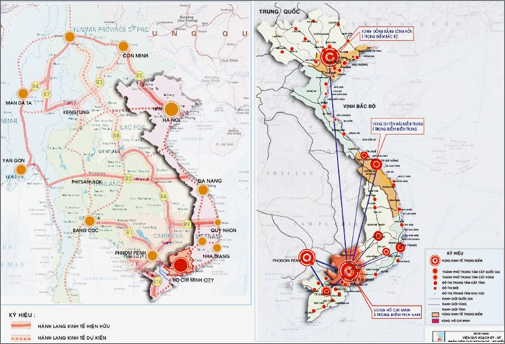
Economic Zones
Currently, Vietnam economic zones are defined by spatial regional plans provided by Ministry of Construction and approved by the government. It comprises 9 zones:
- (1)Hanoi Capital Region including Hanoi, Thai Nguyen, Phu Tho, Bac Giang, Vinh Phuc, Hung yen, Bac Binh, Hai Duong, Ha Nam and Hoa Binh
- (2)Northern Coast: Quang Ninh, Hai Phong, Thai Binh, Nam Dinh and Ninh Binh
- (3)Northen Midland and Mountainous: Ha Giang, Cao Bang, Lao Cai, Bac Kan, Kang Son, Tuyen Quang, Yen Bai, Lai Chau Dien Bien, Son La
- (4)North Central Coast: Thanh Hoa, Nghe An, Ha Tinh, Quang Binh, Quang Tri, Thua Thien Hue
- (5)Central Highlands:Kon Tum, Gia Lai, Dak Lak, Dak Nong, Lam Dong
- (6)Central Southern Coast: Phu Yen, Khanh Hoa, Ninh Thuan, Binh Thuan,
- (7)Key Central Economic Zone: Da Nang, Quang Nam, Quang Ngai, Binh Dinh
- (8)Ho Chi Minh City Region: HCMC, Binh Duong, Binh Phuoc, Tay Ninh, Long An, Dong Nai, Ba Ria- Vung Tau, Tien Giang
- (9)Mekong River Delta: An Giang, Ben Tre, Bac Lieu, Ca Mau, Can Tho, Dong Thao, Hau Giang, Kien Giang, Long An, Soc Trang, Tien Giang, Tra Vinh, Vinh Long
Metropolitan Planning System
The terms of of Metropolitan Planning can be considered as Regional Planning according to Law on Construction 2013, however it is planned for metropolitan regions such as Ha Noi and Ho Chi Minh regions.
The Ministry of Construction is responsible for drawing up regional construction plans of the capital and other metropolitan regions; urban plans that involve more than 2 provinces. The Ministry then seeks the opinions of related agencies and their branches, other relevant ministries, and the centrally-controlled cities' people's committees, related provinces' people's committees after the draft plans are submitted to the Prime Minister for approval.
There are 3 metropolitan regions in Viet Nam which come along with 3 key economic regions, North, Central and South. They are Ha Noi's region, Da Nang and Ho Chi Minh.
There are challenges to implement multi-provincial plannings, because the Constitution does not define multi-provincial governments then there is no government to be in charge of implementing these plannings. Therefore they actually are not effective as expected.
- Hanoi Capital Region Plan (of Regional Construction Planning Category)
- The Plan of The Ha Noi Capital Region was approved by the Decision No.490/QÐ-TTg of the Prime Minister on May 5, 2008. It emphasized that the Region is the area of multi-central poles in which Ha Noi Capital is a core; prefecture-level cities are link poles for multi-directions of the development. The 2008 Plan included 8 centrally-controlled cities/provinces: Ha Noi, Hà Tây, Vĩnh Phúc, Hưng Yên, Bắc Ninh, Hải Dương, Hà Nam và Hoà Bình.
- The review of the 2008 Plan is undergoing and expected to be approved in 2015. The drafting of Hanoi Capital Region includes 10 centrally-controlled cities/provinces: Ha Noi, Phu Tho, Vinh Phuc, Thai Nguyen, Bac Giang, Bac Ninh, Hai Duong, Hung Yen, Ha Nam, Hoa Binh.
- Ha Noi Capital Construction Master Plan to 2030 and Vision to 2050 (which was of one Urban Planning Category) was approved on July 26, 2011 by the Prime Minister with some following spatial contents:
- –After the expansion in 2008, Ha Noi includes the former Ha Tay Province and the former Son Tay City. Due to the 1992 Constitution, there should be no city inside a city. Thus Ha Dong City of the former Ha Tay Province was re-classified as a district of Ha Noi, and the former Son Tay City was degraded to a town.
- –According to the Master Plan, the development model is a conurbation (or an agglomeration) in which there are one Urban Core, 5 urban satellites (Soc Son, Son Tay, Hoa Lac, Xuan Mai and Phu Xuyen), 3 eco-towns (Phuc Tho, Quoc Oai and Chuc Son) and some other townships.
Figure:Ho Chi Minh City Regional Plan
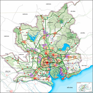
HCMC metropolitan regional planning
Source: Southern Sub-Institute of Urban and Regional Planning, Ministry of Construction, Vietnam
- Ho Chi Minh City Regional Plan (of Regional Construction Planning Category)
- The Planning of HCM metropolitan region was approved by the decision 589/QÐ-TTg signed by Prime Minister on May 20, 2008. It included 8 centrally-controlled cities/provinces: Ho Chi Minh, Bình Dương, Bình Phước, Tây Ninh, Long An, Đồng Nai, Bà Rịa - Vũng Tàu, Tiền Giang.It emphasized that the Region is the area of multi-central poles in which HCMC is a main hub; prefecture-level cities are link poles for multi-directions of the development. Satellite cities are prefecture-level cities concentrated in five main poles:
- –South-East pole: Vung Tau city plays a role as a core in connection with Phu My, Ba Ria, Long Hai city to build up Vung Tau city Region.
- –East Pole includes 7 cities: Dau Giay, Long Thanh, Gia ray, Dinh Quan, Tan Phu, Vinh Cuu and Long Khanh as a core city
- –North pole includes 8 cities: My Phuoc, Chon Thanh, An Loc, Loc Ninh, Hoa Lu, Dong Xoai, and Chon Thanh as a core city
- –North West pole includes 9 cities: Trang Bang, Go Dau, Moc Bai, Tay Ninh, Xa Mat, and Trang Bang, Go Dau, Moc Bai, Tay Ninh as core cities.
- –South West pole includes 4 cities: Ben Luc, Tan An, Tan Hiep, My Tho in which My Tho and Tan An as core cities. Ho Chi Minh Construction Master Planning to 2025 is category of urban planning which approved by Prime Minster in Decision No.24/QD-TTg on 6th Jan 2010.
Ho Chi Minh Construction Master Planning to 2025 is category of urban planning which approved by Prime Minster in Decision No.24/QD-TTg on 6th Jan 2010.
Regional Cooperation with Neighboring Countries for the Development of Border Areas
In order to promote trade across national borders, Viet Nam cooperates with neighboring countries for the development of border areas. The country has set up free trade zones in towns that serve as gateways for crossing national borders. Viet Nam shares with the partner countries the cost of building roads that link the inland area (inside the partner country) with harbors (inside Viet Nam). It is also proceeding with bilateral talks related to power and other elements of infrastructure, human resource development, etc. As of January 2014, Viet Nam has 24 Border Gate Economic Zones (including both railways and roads), the borders of which are shared with China, Laos, and Cambodia.

- Information update:February 16, 2015
- Contributor:MAUD. Arch. Nguyen Du Minh (Vice-Head, Urban Development for Information, International Cooperation and Consultation, Urban Development Agency, Viet Nam)