
Country Profile
The Netherlands comprises three constituent territories: the territory in continental Europe, the Netherlands Antilles, and Aruba.
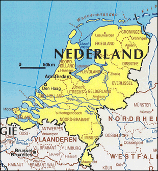
The continental Netherlands is roughly the size of Kyushu in Japan. Most of the country consists of either lowlands along the sea or reclaimed land, with one-quarter of the country at or below sea level. The population density 400/km² is higher than that of Japan (Japan: 342/km² in 2012).
The Randstad region, a conurbation made up of the capital Amsterdam, Rotterdam, the Hague and Utrecht, covers 26% of the territory and is home to 46% of its population.
TableNetherlands fast facts
| Country name | Kingdom of the Netherlands |
|---|---|
| Surface area | About 41,864 km² (about the same as Kyushu) |
| Population | Approximately 17.05 million (2016.8: Statistics Netherlands) |
| Population density | 407/km² |
| Percentage of urban population | 90.5% (2015) |
| GDP | USD 7,384 billion (2016.4: IMF) |
| GDP per capita | USD 43,603 (2015) (2016.4: IMF) |
| Percentage of employment by industry | agriculture: 1.6% industry: 17.8% services: 70.4% (2016 est.) |
| Economic growth rate | 1.1% (2010), 1.7% (2011), ▲1.6% (2012) ▲0.7% (2013), 0.9% (2014), 1.9% (2015) 1.8% (2016) (2016.4: IMF) |
(Information Updated: March 2017)
Local Governments
Referred to as a decentralized unitary state, the provinces and basic municipalities of the Netherlands have the obligation to engage in joint administrative work, which is delegated by the national government, in addition to performing their individual administrative work as autonomous bodies. Further, the heads of the provinces and municipalities are appointed by the royal command of the king. The provinces have less responsibility as compared with the prefectures in Japan.
The country is comprised of 12 provinces and 418 basic municipalities (as of 2010). As the result of merger, the number of municipalities decreased from 431 of 2009.
Alongside this structure, diverse types of regional administrative organizations composed of multiple municipalities have developed (such as city-regions), however the coalition government established in October 2010, advocating "small government", has given out the policy of abolishing the city-regions (not yet implemented).
Local Governments and Spatial Planning System
Major Authorities Relating to Spatial Policy
| Policy Area | Authority | Web Site |
|---|---|---|
| Spatial planning Water resources management |
Ministry of Infrastructure and the Environment | http://www.government.nl/ministries/ienm |
| Housing Policies | Ministry of the Interior and Kingdom Relations | http://www.government.nl/ministries/bzk |
| Regional policies | Ministry of Economic Affairs | http://www.government.nl/ministries/ez |
| Amsterdam Metropolitan Area | Metropoolregio Amsterdam | http://www.metropoolregioamsterdam.nl/ |
The Netherlands, comprising low land surrounded by water, has traditionally implemented comprehensive national spatial policies as exemplified by the creation of polders following the flood of 1916 and the delta plan subsequent to the flood of 1953.
Its efforts on spatial planning date back to the Housing Act (Woningwet)of 1901. While the post-War emphasis was on reconstruction and the resolution of housing shortage, principal issues have been changing from time to time since 1960, when the government began to publish its spatial policy, and range from the development of growth centers outside the Metropolitan area and market-oriented urban policies.
As regards regional policies, regional disparities within the country have been very limited as compared with other European countries. Although support had traditionally been provided mainly to regions in the periphery, the country decided in 2006 to end traditional regional policies and place emphasis on supporting regions that contribute to national economic development in order to enhance its competitiveness and promote innovation.
Spatial Planning Authorities
The Spatial Planning Act (Wet op de Ruimtelijke Ordening, WRO), which governs spatial planning and urban planning separately from housing, was legislated in 1965.
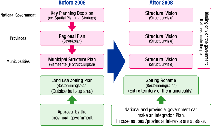
- Traditional Spatial Planning System
- The national government was to make the key planning decisions, the provinces were to devise provincial regional plans covering broad regions, the municipalities were to devise structural plans, and lower level governments were to abide by the national key planning decisions and the provincial regional plans.
- The municipalities were to devise land use zoning plans, which required provincial approval.
- National Guidelines (2012 Structural Vision on Infrastructure and Space)
- National spatial policy guidelines were prepared four times in the past since 1960. (The fifth policy guidelines in 2001 were not finalized.) In 2006, the "National Spatial Strategy (Nota Ruimte) -- Creating Space for Development" (covers the period through 2020, but includes 2020-2030 in the long term) was formulated. Unlike the traditional national spatial policy guidelines, regulations by the national government is reduced and local discretion is given weight in the strategy, and also the content is diversified, ranging from socioeconomic development to action agenda regarding national investment priorites.
- In association with change of government in 2010, Structural Vision on Infrastructure and Space (Structuurvisie Infrastructuur en Ruimte (SVIR)) was established in March 2012 and it became to replace National Spatial Strategy.
- SVIR sets out as a long-term prospect the goal of "competitive, accessible, habitable and safe Netherlands" which is also shown as its subtitle, and it states as the mid-term objectives toward 2028; i) improve competitiveness by strengthening spatial economic structure, ii) upgrade and secure accessible space with first priority to users and iii) secure sustainable and safe environment which maintains rich nature and high cultural and historical value (see the figure on the right: National Spatial Structure).
Figure:National Spatial Structure - Economy, Infrastructure, Urbanization
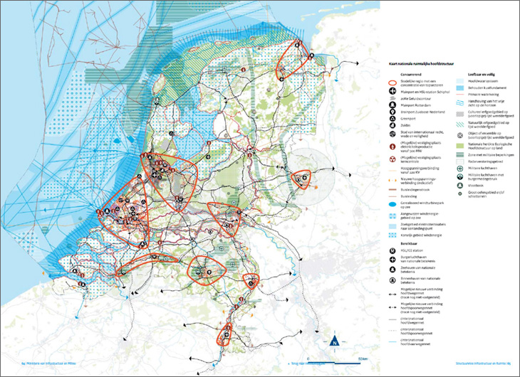
Source: Ministerie van Infrastructuur en Milieu (2013) "Structuurvisie Infrastructuur en Ruimte"
- Fundamental Amendment of Spatial Planning Act
Intent Given that the Spatial Planning Act had become complicated due to repeated amendments, a fundamental amendment thereof intended to achieve the simplification of decision-making procedures and ensuring effectiveness, among other things, was put into effect as of July 1, 2008.
The delegation of authority to local governments and other matters, which were also set forth in the National Spatial Strategy, were promoted to strengthen planning by basic municipalities and expedite the decision-making procesures for spatial planning. The Land Development Act concerning the sharing of land development costs was also enacted concurrently with the New Act.Spatial planning system National, provincial, and basic municipal government plans were all replaced by structural visions (Structuurvisie). Structural visions, which are related to strategic policies, set forth the basic principles of spatial policies, as well as the mode of execution of the policies. Unlike before, the national and provincial structural visions are internal guidelines and are not binding on lower level governments. Land use and zoning
(Bestemmingsplan)While the municipalities have always devised the land use zoning plans for non-developed areas, the new Law required that they devise and update zoning plans for all areas. The Law permits the municipalities to devise plans without provincial approval, and enables the provinces and the national government to devise an adaptation plan (Inpassingsplan) with respect to land use zoning that affect their respective interests.
The Spatial Planning Act is expected to be integrated in the system of Environment Act (Omgevingswet) together with other laws and decrees such as Environmental Management Act and the draft Environmental Act which unifies 26 environment-related laws was submitted to House of Representatives in June 2014. The aim of the integration is regarded as the simplification of procedures to speed up decision making process in order to ensure consistency with spatial plans and projects/activities related to environment and nature and to enable application of laws conform with the current situation of the regions, and the legal system of spatial planning is going to be amended as well. Environment Act is scheduled to be enforced in 2018.
Metropolitan Area and Spatial Planning
Plans are being devised on multiple levels with respect to areas related to the capital.
- Randstad Region
- Amsterdam, the Hague, Rotterdam, and Utrecht comprise the metropolitan network Randstad. Since the National Spatial Strategy does not refer in detail to subjects such as investment in the infrastructure of this region, the country announced a structural vision on the future of the region with a view to 2040 entitled "Randstad towards 2040" in September 2008, given the importance of the region.
- Furthermore, Randstad 2040 has been decided to be replaced by Structural Vision on Infrastructure and Space.
- Amsterdam Metropolitan Area
- The Amsterdam Metropolitan Area (also referred to as North Wing of Randstad), comprising the capital Amsterdam and the Schiphol Airport, formulated the "Amsterdam Metropolitan Area Development Scenario 2040" in 2007 in order to address such issues as the strengthening of the area's international competitive power or the climate change. The Scenario, which is based on an informal regional collaboration encompassing 36 basic municipalities, two provinces, and one city, also serves as the basic policy for the formulation of structural visions by the municipalities pursuant to the new Spatial Planning law. It also provided input in the formulation of Randstad towards 2040.
- City of Amsterdam
- In accordance with the New Spatial Planning Act, Structural Vision was established in February 2011. It's subtitle is "Strong Economy and Sustainability" and it is characterized, as a result of collaboration with the surrounding municipalities, by its vision reaching beyond the city sphere.
Other: Efforts for New Delta Act
In response to the increase in water levels of the ocean and the rivers in recent years due to global warming, the Delta Committee, which studies anti-flood measures, made recommendations on the safety strategy for the next 100 years to the Minister of Transport, Public Works and Water Management in September 2008, and stated that while the Netherlands is safe in the short term, enhancement of measures is required in the long term. In addition to incorporating the recommendations into the First National Water Plan, the national government is scheduled to submit the concept for the New Delta Act by the end of 2009. The National Water Plan was published in December 2009, and the draft of New Delta Act was submitted to the parliament in 2010 then became effective in January 2012.
(Information Updated: March 2015)