
Country Profile
Table 1Philippine Fast facts
| Country name | Republic of the Philippines |
|---|---|
| Surface area | 299,404 km² (made up of 7,109 islands) |
| Population | About 109.8 million (2016) |
| Population density | 337/km² |
| Percentage of urban population | 44.4% (2015) |
| GDP | USD 168.5 billion (2009) USD 199.6 billion (2010) USD 224.1 billion (2011) USD 250.1 billion (2012) USD 272.0 billion (2013) USD 284.8 billion (2014) USD 292.0 billion (2015) |
| GDP per capita | USD 1,851 (2009), USD 2,155 (2010) USD 2,364 (2011), USD 2,591 (2012) USD 2,770 (2013), USD 2,844 (2014) USD 2,858 (2015) |
| Percentage of employment by industry | agriculture: 29% industry: 16% services: 55% (2015 est.) |
| Economic growth rate | 1.1% (2009), 7.6% (2010), 3.6% (2011) 6.8% (2012), 7.2% (2013), 6.1% (2014) 5.8% (2015) |
(Information Updated: March 2017)
The Republic of the Philippines is an archipelagic nation made up of more than 7,000 islands stretching 1,851 km from north to south. About 1,000 of its islands are inhabited, and less than one-half of these islands are larger than 2.5 km²; it is approximately 800 km from mainland Asia and is located between Taiwan and Borneo (“Geography of the Philippines” 2016). The 11 largest of its islands, which include Luzon, Mindanao, Mindoro, Samar, Leyte, and Cebu, make up 96% of the country's surface area.
The Philippines is one of the most urbanized developing countries in Asia with about half of the population currently living in urban areas, a figure that began as early as 1990.
There is a large disparity between the rich and the poor, thereby making poverty reduction one of the most pressing tasks that the country faces. Three (3) quarters of the poor live in rural areas, while only 10-percent of rich Filipinos hold 76-percent of the country's wealth (De Vera 2014). Situated in this predominantly Roman Catholic country (accounting for 93% of the population), the Autonomous Region in Muslim Mindanao (ARMM) in southern Philippines particularly suffers marked underdevelopment (Figure 1).
Figure 1The Philippines and its 17 regions
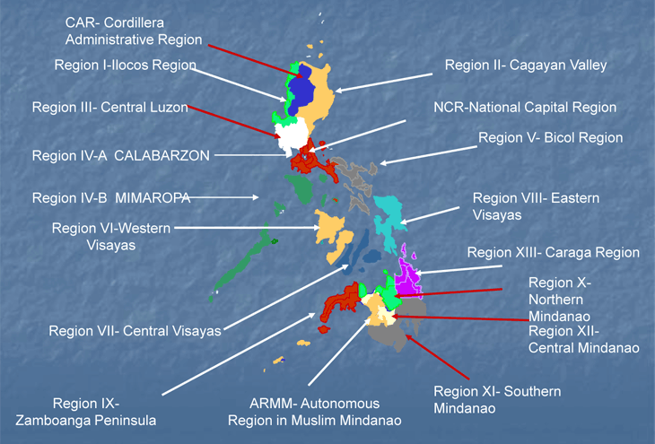
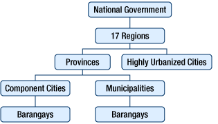
Figure 2Political/administrative system
Sources: Report on the 2008 National Spatial Policy Seminar, MLIT National and Regional Planning Bureau, 2009
Local Government System
The local government administrative system in the Philippines is three-tiered, consisting of: 1) provinces and highly urbanized cities, 2) cities as “component cities” and municipalities, and 3) barangays as the smallest administrative unit (Figure 2).
A notable feature of local governance in the Philippines arose from the Marcos dictatorship (i.e. highly centralized governance) and culminated in the EDSA People Power revolution of 1986; that of administrative devolution and autonomy favoring local government units or LGUs (Philippine Constitution 1987). Granting more power, authority, responsibility and resources by the national government to its local counterparts, the former seeks engagement of the latter to have “more freedom in carrying-out programs suitable for their areas” and to be more “self-reliant and active partners in development” (Dorotan, n.d.). This governance strategy is enacted through Republic Act 7160, a national law otherwise known as the Philippine “Local Government Code of 1991”.
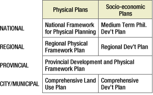
Figure 3Planning system
Sources: Report on the 2008 National Spatial Policy Seminar, MLIT National and Regional Planning Bureau, 2009
Planning System
The planning system as it relates from national to regional levels entail spatial planning and socioeconomic development planning. There are plans under both of these frameworks that are implemented at the regional level, a region in this case being a division created out in order to bunch multiple provinces together for nominal administrative purposes.
In the local level (i.e. provincial, particularly city/municipal level), spatial and socio-economic planning variants (Figure 3) are manifested in the Comprehensive Land Use Plan (CLUP) and Comprehensive Development Plan (CDP); with the former (i.e. CLUP) seeking to manage territory and the latter seeking to promote the improved general welfare of inhabitants (Philippine Local Govt Code 1991).
Major Authorities Relating to Spatial Policy
The National Economic Development Authority (NEDA) is the primary government agency in charge with the formulation of national and regional planning policy in the Philippines. However, in recognition of the primacy of Metro Manila as a “special development and administrative region” (IRR-MMDA 1996), alongside the strong local autonomy entrusted to the 17 local government units or LGUs comprising it (Philippine Local Govt Code 1991), the Metropolitan Manila Development Authority (MMDA) was designated to be in-charge of directing the capital region's development that not only integrates NEDA national policy but also reconciles the various local considerations championed by each of the cities and municipality comprising Metro Manila.
Table 2Major authorities relating to spatial policy
| Program name or administrative field |
Organizations | Webpage |
|---|---|---|
| Medium-Term Philippine Development Plan | National Economic and Development Authority | http://www.neda.gov.ph/ |
| National Framework for Physical Planning | National Economic and Development Authority | http://www.neda.gov.ph/ |
| Physical Framework Plan for Metropolitan Manila | Metropolitan Manila Development Authority | http://www.mmda.gov.ph/ |
Socioeconomic Planning at the National and Regional Levels
A Medium-Term Philippine Development Plan (MTPDP) remains in force for six years, corresponding to the term of office of the country's president (however, the recent plan is a five-year plan, “Philippine Development Plan 2011-2016”, starting from the second year of the presidency). It is a national program that outlines the policies the president wishes to institute during his or her term. MTPDPs corresponding to presidential terms came into being in 1986; replacing the four-year and five-year plans that had continued since the 1970s. The next MTPDP is expected after the presidential elections scheduled in the month of May in 2016.
MTPDPs lay out major policy initiatives, socioeconomic strategies, and major national programs. Regional development plans, meanwhile, stipulate strategies, programs and projects that facilitate the goals of the national plans.
The National Economic and Development Authority (NEDA), charged with drafting the MTPDPs, coordinates with related agencies in formulating the plan. The final product is subject to the approval by a NEDA committee made up of government cabinet members (the “Cabinet Committee”) and chaired by the president.
The NEDA's drafts for the national development plan and its policies serve as the basis for drafting, reviewing, and deliberating the regional development plans. Regional Development Council (RDC) organized in each region is the counterpart of the NEDA regional office established in each region (except for NCR, as well as ARMM) in deciding how plans should be implemented at the regional and local levels. Each RDC is made up of regional/local representatives, representatives from government arms in the region, and members of the private sector.
Physical Planning at the National and Regional Levels
Rooted in the notion that spatial planning should be done from a long-term perspective, the 30-year “National Physical Framework Plan, 1993-2022” (NPFP) was formulated. The current plan was renamed the “National Framework for Physical Planning, 2001-2030” (NFPP). Quoting Villarete in his article entitled “Physical Framework Planning”:
The NPFP was formulated as an integrated national land use policy agenda that would guide the allocation, utilization, development and management of the country's physical resources. It was approved in 1992 and had a planning horizon of 1993-2022. In 1997, however, it was replaced by the National Framework for Physical Planning 2001-2030, with a vision of national development anchored on sustainable development and growth with social equity. Again, the key word in all these plans is “physical” as against “economic”; with physical planning having a longer planning horizon (30-50 years) than the usual 5 years for economic plans.
The other key term is “framework,” which suggest a generalized concept rather than a detailed blueprint for development. It is a physical plan upon which the shorter (and more detailed) “medium-term” socio-economic plans are based. The “physical framework” also suggests connectivity, and that's why systems of urban settlements and transportation networks are more often than not included here rather than in the economic plans. Rightly so because the development of transport networks and other infrastructure also requires longer periods not available in medium-term plans (Villarete 2014).
The NFPP lays out policies and initiatives related to the distribution, utilization, management, and development of land and material resources. The ultimate purpose of the plan is to raise land productivity, protect and ensure the sustainability of resources, facilitate the coherent development of housing, and build an infrastructure that helps promote or assist in development. Similar to NPFP, NFPP was established through the office of NEDA by NLUC (National Land Use Committees), which consists of related ministries and is in close connection with NEDA. Today NLUC is positioned as one of the subordinate committee of NEDA committee (its position was changed by Executive Order No.770 in 2008.)
There was a reason behind the name change from NPFP to NFPP. The previous plan restricted the actions of the lower-tiered administrative authorities. The new framework, in contrast, is designed to relieve such restrictions and give local authorities more say in policy decisions (i.e. consistent with local autonomy policy enshrined in the constitution).
In a development that paralleled the creation of the NFPP, at the regional level, Regional Physical Framework Plans (RPFPs) came to be drafted. Just as with the NFPP, the RPFPs presented local authorities with choices and directions for policy. The national and regional NEDA offices direct the creation of RPFPs (except for NCR and ARMM), while each RPFP is approved by the concerned Regional Development Council (this also excludes NCR and ARMM, and also CAR). Except for two regions (NCR and CAR), target year of current RPFPs of all the regions including ARMM is 2030. Although there are reports that the current NFPP is planned for review just 15-years after its beginning year, as of this writing (2016) the current NFPP 2001-2030 is still the current national physical framework plan espoused by the Philippine national government.
Figure 4Zoning map of Metro Manila
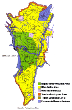
Source: Physical Framework Plan for Metropolitan Manila 1996-2016, MMDA, 1999
Metropolitan and Regional Planning
The national capital region of Metropolitan Manila (NCR or Metro Manila) is the only urban area in the Philippines of which its geographical area and administrative power is legally defined by a 1995 law creating the Metro Manila Development Authority or MMDA (RA 7924 1995); though there are cases outside NCR where a big city and its surrounding local government units name themselves as a metropolitan area as well (e.g., Metro Cebu, Metro Davao)*. However, the administration of these metropolitan areas is based in voluntary agreement among concerned LGUs, with a legal basis solely embedded in the 1987 Constitution and the Local Government Code of 1991.
The Metropolitan Manila Development Authority (MMDA) as a government agency came into being in 1995, issuing its first spatial planning document entitled “Physical Development Framework Plan for Metropolitan Manila, 1996-2016” (PDFPFMM). The plan was amended in 1999, but its name and planning period remained as it was in 1996.
Almost 2 decades later, the MMDA realized that “there is a need to revise the plan in view of significant changes in the economic, social, and environmental conditions in the metropolis” (Llorito, Hermoso, and Al-Arief 2012). In response to this, the “Metro Manila Green Print 2030” was launched in March 2012, aiming to transform the capital region into “a highly competitive Southeast Asian metropolis, raising the standard of living for its residents by providing a framework for integrated management of complex issues within Metro Manila, including coordination among the National Capital Region's 17 local government units” (Lapena 2012). Currently, the aspired spatial development factors (e.g. development opportunities and challenges, as well as resulting spatial planning concepts) for the region have been identified and released through the “Metro Manila Green print 2030: Building a Vision” report (Zhang et al. 2014). The production of its more detailed and binding regional development maps - due for release in 2016 - is ongoing.
In the course of developing the Metro Manila Green Print 2030, MMDA plays the role of a NEDA regional office, as is the case with other regions; with metropolitan plans established through the approval of the Metro Manila Council (MMC), which corresponds to the Regional Development Councils (RDCs) of other regions. MMC is the policymaking organization of MMDA that consists of all the cities' and municipalities' mayors in NCR and was given the status as a RDC by an executive order in 2002.
- *The Autonomous Region in Muslim Mindanao (ARMM) – like Metro Manila - also has the distinction of having its geographical area and administrative power to be legally defined by law (Republic Act 9054). However, the ARMM is composed mainly of rural areas namely the provinces of Basilan, Lanao del Sur, Maguindanao, Sulu and Tawi-Tawi; only the cities of Marawi and Lamitan are of urban character (“ARMM History,” n.d.).
The Philippine Development Plan 2011-2016 (PDP) sets out an “Industrial Cluster Strategy” to promote creation of industrial clusters (geographical accumulation of specific industry) reflecting industrial activity and infrastructural character of respective domestic area that will contribute to the creation of regional wealth through export (Figure 5).
In this strategy of developing industrial clusters, the government intends to promote fostering of inter-business cooperation between small and medium tiny companies to strengthen network toward collaboration; based on the understanding that the past development policy had led the country to “fall into the path of a trickle-down jobless growth” (words from the Preface of PDP. Trickle-down is an economic thought that expresses vitalization of economic activities of large enterprises and wealthy class will make a stream of wealth pouring down onto low-income class that will finally bring benefit to the whole nation).
Beyond industrial clustering, newly emerged challenges and threats to national and regional development (such as transport/traffic management in Metro Manila and surrounding provinces; effect of climate change manifested through “super typhoons” such as Yolanda / Haiyan battering the Eastern Visayas region) have led to the creation of complementary policy and plan directions by the Philippine government so as to better address these planning concerns.
An example of which is that of National Economic Development Authority or NEDA's (with the assistance of JICA) release of a “Roadmap for Transport Infrastructure Development for Metro Manila and its Surrounding Areas”; a plan that contains improved urban mobility policy directions for the capital region and its surrounding environs. Moreover, it was found to be in consonance with the previously discussed efforts to create a “Metro Manila Greenprint 2030” as espoused by the Metropolitan Manila Development Authority (MMDA). Another example is the creation of the “Regional Development Plan for Eastern Visayas 2014-2016” region and “Yolanda Reconstruction Plan”; in response to the effect of typhoon Yolanda/Haiyan that hit Eastern Visayas in November 2013.
Figure 5Industry cluster strategy, 2011-16
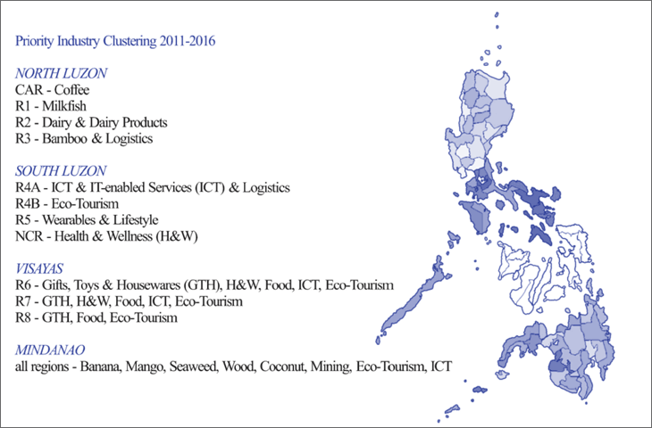
Source: Philippine Development Plan 2011-2016, NEDA, 2011

- Information Update:
March 11, 2016 - Contributor:
Mark Anthony Mateo Morales, Dr. Eng.
Director, Training and Extension Services Division, Assistant Professor
School of Urban & Regional Planning, University of the Philippines